A Typology Analysis of Lithic Artifacts Recovered from a Middle Woodland Site in North Georgia
William Heflin (Kennesaw State University)
The prehistory of the Southeastern United States is divided into four broad periods: the Paleoindian period, the Archaic period, the Woodland period, and the Mississippian period. The Woodland period dates from ca. 1000 BC to AD 1000. Within this time period is the Middle Woodland period, which dates from 300 BC- AD 600. There are many factors that distinguish the Woodland period from the other periods. In north Georgia specifically, ceramic styles such as Cartersville Simple and Check Stamped emerge (Wood and Bowen 1995, 12). Housing structures of this time were round or oval shaped and villages were often concentrated near rivers (Hudson 1979, 62). In terms of lithic artifacts, triangular points became common during this time (Keith 2010, 10). The dietary structure of the Woodland people consisted of a mixture of plants and animals. The agriculture at this time seems to conform to the Eastern Agricultural Complex (Hudson 1979, 60). The EAC included crops such as starchy and oily seeds, squash, sunflower seeds, and nuts (Espenshade and Patch 2005, 40).
The Lower Dabbs site is a small village located on the first terrace of the Etowah River in Bartow County, Georgia. This site corresponds with the cultural phase known as the Cartersville phase (Wood and Bowen 1995, 11-13). Lower Dabbs sits directly on the opposite side of the river from the Leake site, the pre-eminent Woodland site in the region, near the Etowah Indian Mounds (Figure 1). This site has been the location of an archaeology field school taught by Dr. Terry G. Powis of Kennesaw State University (KSU) since 2015.
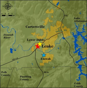
Figure 1: A local map detailing the Lower Dabbs site (yellow star), Leake site (red star), and Etowah Indian Mounds (blue star). Map provided by Terry G. Powis.
Over the past three years of excavations, the Lower Dabbs site has yielded a wide variety of artifacts. Such artifacts include ceramics (including Cartersville Simple Stamped, Check Stamped, and Linear Check Stamped), lithics, shell, and bone materials. These artifacts have all been recovered on a site that is 25 by 25 meters in areal extent (Figure 2). While to date there has not been a confirmed housing structure excavated at the site, features such as postholes containing daub (mud/clay used for building housing structures) suggest that there were one or many structures present at one time. Other features found at the site include a potential hearth, refuse pits and storage pits. One of these features (feature 120) produced not only charcoal, but also dateable ceramic and lithic artifacts (Figure 3).
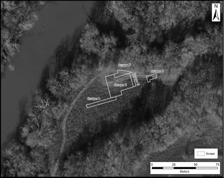
Figure 2: An aerial map of the Lower Dabbs site. Map produced by Jeff Turner.
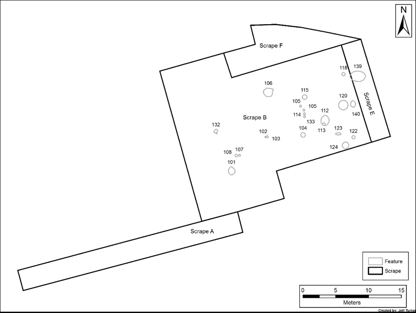
Figure 3: A map of features excavated at the Lower Dabbs site. Map produced by Jeff Turner.
To date, the only research performed on artifacts from the site has been on decorated ceramics found in features. Therefore, this project will be the first research on the lithic artifacts that have been recovered at Lower Dabbs. I believe that while a wide range of knowledge can indeed be gained from ceramic research, just as much can also be gleaned from the analysis of the lithic materials. Performing the first analysis of lithic artifacts found at Lower Dabbs will allow for a new perspective when understanding those prehistoric inhabitants who occupied it.
Lithic artifacts, as defined by William Andrefsky Jr, are any culturally modified stone tools or debitage (debris created as a result of the lithic reduction process) material found on prehistoric sites (Andrefsky Jr 2005, 11) (Figure 4). These tools are created in a process known as lithic reduction. In the lithic reduction process, the tool starts as a large core, then flakes and other debitage are knapped off to form what is called a preform. Finally, the preform is further worked until all that is left is the stone tool. In certain cases, flakes themselves can be re-touched and even used as tools. While numerous stones can be worked to create these tools, the highest frequency represented in my analysis was chert (though I also had a wide variety of chert colors and quality), followed by quartz, and in one case quartzite. Lithic analysis refers to the sorting, typing, and further analyzing in order to properly identify what the tool is and what purpose it
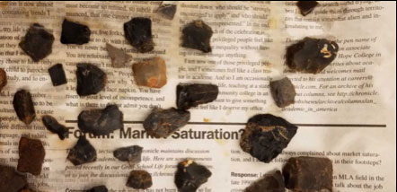
Figure 4: A collection of Lithic Artifacts (made from chert) excavated from the Lower Dabbs site. Such artifacts include flakes, shatter, and incomplete tools.
may have served.
The purpose of this project was to perform the analysis on the lithic artifacts recovered from the Lower Dabbs site. Once this analysis was performed, certain cultural questions were raised and answered by the research. Such questions include: whether or not any trends were present in the tools or the materials used to make them; which materials were most common (and why), do any of the artifacts (or materials) suggest trade; understand and justify the presence of earlier type points; explaining how lithic analysis can be combined with other forms of dating; and analysis to give more accurate dates to prehistoric sites such as Lower Dabbs.
Research Process
The first step of my work was collecting and sorting through all relevant materials to my research. This meant going through each artifact bag from the site individually and separating lithic artifacts from anything non-lithic, including ceramics, bone, and natural materials. For the most part, all of the artifacts were recovered from the site in the past three years of field school excavations. Once the lithic material had been separated, relevant materials were selected and isolated from the assemblage. These materials included complete and incomplete projectile points and PP/K’s, incomplete tools (bifacial or unifacial), flake tools (flake debitage that had been reworked and possibly utilized), preforms and shale/slate tools. The most common artifacts and the most useful for analysis were projectile points and PP/K’s. The term “PP/K” (Projectile Point/ Knife) refers to points that are asymmetrical, whereas most projectile points are symmetrical (Figure 5). Though PP/K’s are typically flat on one side, they are similar to the points in that they adhere to the same classifications and can be typed the same way as projectile points. In some cases, the resources used for typing the points even acknowledged that certain versions may be asymmetrical and used as a PP/K. Every artifact removed was given its own individual artifact bag and tag. For every artifact removed, an empty bag with a duplicate tag was placed in the original bag to allow for the artifacts to be reintegrated properly when the research is completed.
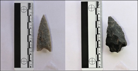
Figure 5: A Yadkin Projectile Point (left) compared to a Bakers Creek PP/K (right). Photographs taken with the assistance of Patrick Severts and Terry G. Powis.
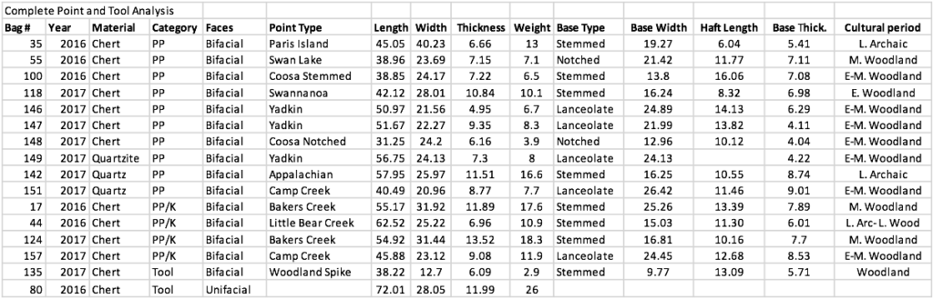
Once all of the material relevant to my study had been removed from the overall assemblage of artifacts, a catalog had to be created using Microsoft Excel in order to keep track of all that had been removed. The first spreadsheet was very basic, and accounted for all of the materials recovered in the order they had been found by date, provenience information, material, and type of tool. Once this was done, more specific spreadsheets were created to account for all of the information that could be gained from the materials. One of the more important spreadsheets accounted for all of the metric information available for the complete projectile points and knives. Another sheet explained the metrics available from incomplete/ broken materials, and dates and time periods for complete points and PP/K’s. Appropriate sheets were also made for all other artifacts analyzed.
For the majority of the artifacts, measurements were taken in millimeters using a pair of digital calipers. In certain cases where the artifacts were too large (such as the shale/slate tools) measurements were manually taken using a basic ruler. Weights were only taken for the complete artifacts, and were taken in grams using a digital scale.
All of the complete projectile points and PP/K’s were successfully typed using a wide variety of resources, both printed and online. One of the most crucial printed works used was that of John S. Whatley, whose 2002 special issue article in the Society for Georgia Archaeology detailed all of the projectile points and other such tools that had been found in the State at the time. Other printed works included digital copies of archaeological reports on other sites local to the Lower Dabbs site, shared with me by my advising professor (Terry Powis). Such sites included the Leake site (Keith 2010) and the Hardin Bridge site (Espenshade and Patch 2005). Online resources were also used in some cases. Such resources include the Georgia section of the online projectile point database (projectilepoints.net), and the projectile point section of the Peach State Archaeological Society website.
In addition to this paper, earlier versions of my research were presented in the spring of 2018 at both the Georgia Academy of Science and KSU’s Symposium of Student Scholars. This research in its most recent form was also recently presented for the mandatory practicum presentations for anthropology majors in the Department of Geography and Anthropology at KSU. For all of these presentations, high quality photographs of the artifacts used in the research had to be taken to give the best visual depiction of this work. While the Anthropology Department does have their own photo set-up, the lighting proved to be unsatisfactory for displaying all attributes of the analyzed materials. To allow for higher quality photographs to be taken, I drove down to LaGrange, Georgia to use the photo set-up of Patrick Severts, which combines both LED bulbs and natural light. For these photos, all of the complete points and tools were photographed, while representative samples of all other categories were also photographed. The main issue we noticed was that darker colored cherts were more difficult to photograph.
Aside from the difficulty in photographing certain artifacts, other difficulties and complications were also presented during the course of this research. First, not all of the sources were consistent in their data, and in some cases data from one report conflicted with data from another. In some of the local site reports, the photographs of the points recovered did not resemble those in other sources. One issue was the photographs given of points from various sites. Some of the points photographed and typed from one site would look unlike points of the same name photographed and typed from other site reports or online databases. Additionally, in regards to photography, some of the photos of lithic artifacts found at other sites were less than ideal. In certain cases, the only photos of lithic artifacts taken were in black-and-white and were less useful in identifying certain defining characteristics of the points.
Another issue was the lack of attention given to lithic artifacts overall recovered from some of the local sites. For instance, I found in many reports that the metric information available in some of these reports were lacking, and in some cases not all of the metrics were even available. For some of these reports, only the mean and average values of a certain typed point was included as well as the number of such points that were recovered, rather than including the metrics for each point of a specific type. For the most part, I found that most of the attention was given to ceramic artifacts recovered from most sites, and lithics were scarcely analyzed. There were also some cases in which lithic analysis was limited to just photographs of the artifacts and acknowledgements that certain points and tools were present at the sites.
A final issue presented in this research was the lack of recent articles and works to perform analysis. Some of the articles used as references in my research were much older than the current research. For example, the Whatley article used to type most of the points analyzed for this research was published in 2002. When using this article, some of the measurements may have been confirmed, but photographs and other information was double-checked using online sources and other site reports. Additionally, when attempting to understand different types of stones used to make tools and where such material can be found, the most credible information came from an article published by Sharon Goad in 1979. Due to the age of this article, some of the findings contrasted that which was found at the Lower Dabbs site. In one instance, Goad claims that people living in this region of Georgia at the Middle Woodland time period would have been using quartz and quartzite to create their tools (Goad 1979, 65-66). While this will be discussed later in more detail, the majority of tools recovered were made from chert, whereas very few were made from quartz and only one was made from quartzite.
In one instance, we were presented with an online application that claimed to be able to type points using an AI database. Though initially skeptical, I decided to at least see how accurate it was. Every time I uploaded a picture I received an error message. Through further investigation I found that the application had been started but never completed, and the database was only utilized on a small number of points.
Results/ Findings
The grand total of artifacts recovered and used for this research is 158 artifacts. This total is divided into the following broad categories:
Complete Artifacts
Sixteen complete artifacts were recovered and analyzed in this research. Complete points are those where all material is present from tip-to-base. This total is broken down into 15 complete projectile points (11 points, four PP/K’s), and one complete unifacial blade. The complete unifacial blade is often disregarded, as no reliable sources were found on typing unifacial lithic tools.
Incomplete Projectile Points
Incomplete projectile points represent points or possible PP/K’s that are broken, but enough material was still present to designate the artifact as a point or knife rather than some other form of tool. A total of 44 artifacts, were included in this category. Of these 44 artifacts, 21 had enough material present to be typed as projectile points or PP/K’s.
Incomplete Tools
The incomplete tool category represents artifacts that show signs of being worked on one or both sides, but are missing the necessary portions to be designated as a projectile point or PP/K. For the most part this section consisted of chert and quartz midsections or tools that had no bases, as bases were crucial for typing the points. A total of 47 incomplete stone tools were recovered.
Preforms
Preforms, as defined in the Andrefsky book, represent the stage in lithic reduction right before the finished product (Andrefsky Jr 2005, 260). These often look like stones with the shapes of a tool, but have not yet been worked on the sides. Thirty preforms were present in the assemblage.
Flake Tools
Flake tools, as defined by Andrefsky, are tools where a flake (a form of debitage created when making a lithic tool) had signs of being reworked and possibly used (Andrefsky 2005, 255). Fourteen such tools were present.
Shale/Slate Tools
The final category was shale/slate tools. These are pieces of shale or slate rock which have been worked (often their edges were rounded) into a potential tool, however little research was done on these as all of them were broken. Seven such artifacts were recovered. Originally, this name “shale/slate” was a catch-all title to account for the small amount of these tools, but with the help of Patrick Severts this total was divided into four shale and three slate tools. These tools were not given too much attention, as they were all incomplete and unable to be analyzed.
Discussion
Lithic Trends
To create the typology for the site, the 15 complete points (Appendix A) were combined with the 21 incomplete points that had enough material to be typed (Appendix D), giving a total of 36 artifacts that could be typed. The following is a list of the types that to date have been identified through these 36 artifacts, as well as how many of each were observed: five Yadkin, four Camp Creek, two Bakers Creek, two Woodland Spike, three Coosa (one stemmed and two notched), one Otarre, one New Market, one Appalachian, one Swan Lake, one Kirk Serrated, one Mississipian Triangular, two Hernando, two Paris Island, three Swannanoa, two Ebenezer, two Little Bear Creek, and two Savannah River (Appendices A and D). Of these types, the two most popular are Yadkin (five) and Camp Creek (four). A unique feature of both types is that they adhere to the triangular style that is observed in many Woodland period lithics.
Dating Using Lithics
Previously, dates for the Lower Dabbs site came exclusively from a combination of ceramic analysis and radiocarbon dating from features at the site. While these are two valid methods of dating a prehistoric site, my research allows for a lithic perspective to be introduced to the site for the first time. However, this is best performed by using artifacts recovered from features, as any artifact excavated from a feature still has its cultural context. Feature 120 gives a perfect example as to how all three methods of dating may be used together to confirm the dates of a site. In this feature, Cartersville Simple Stamped and Dunlap Fabric Marked ceramic sherds were recovered, which are associated with dates from 300 BC- AD 600. Additionally, radiocarbon dates taken from charcoal samples near the pottery dated from 360 BC- 170 cal BC. In terms of lithics, three complete Yadkin points (known to date 500 BC- AD 600) and one complete Coosa Notch point (500 BC-AD 500) were recovered (Appendix B). The combination of these three dating methods, combined with the known time period of the Middle Woodland highly suggest a long Middle Woodland habitation at the Lower Dabbs site (Figure 6). As quoted by Scot Keith’s report of the nearby Leake site, “Coosa and Coosa notched PP/Ks appear in northwest Georgia, commonly occurring in association with fabric marked and simple stamped wares; these related types continue into the following Middle Woodland period.” (Keith 2010, 10). Additionally, while the majority of other points were found during the surface collection or excavation units (thereby not being in the cultural context associated with features), most of these points were also typed with dates in the Woodland period (Appendix B).
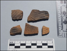
Figure 6: A collection of Cartersville Check and Simple Stamped pottery sherds (left) alongside Yadkin and Coosa projectile points (right), all of which are known to be associated with the Middle Woodland period.
Interestingly, some of the typed points date to an earlier time period (Appendix B). Examples of such points include the Appalachian point (2500-1500 BC), the Paris Island point (2700-2200 BC), and the Savannah River point (2150-1800 BC). The dates of all of these points are somewhere within the time period known as the Archaic period. While these artifacts may be less useful in dating the site, their presence can still be explained. One explanation is that there may have been people in the area before the time that the Lower Dabbs site was actually settled. The proximity to the river would have likely drawn people to collect water, so perhaps one of these large Archaic type points could have fallen from their pockets. Additionally, the water would have likely attracted animals as well, so this area could have been a hunting ground at that time. To this date, the attraction to game animals can still be observed, as during my time at the field school I often observed many herds of deer approaching my car, at some points even sprinting directly in front of it.
Another possible explanation is the aesthetic or collectors’ value. Similar to how modern people appreciate antiques and other old/vintage items, the Middle Woodland people at the Lower Dabbs site may have also had an eye towards older artifacts. There is potential that to them, these had historical significance and may also have been valued as antiques.
In addition to the typed points from the Archaic and Woodland periods, one point also was typed and dated to the more recent Mississippian period. This incomplete point is called the Mississippian Triangular point, and resembles a much smaller version of a Yadkin style point. This allowed me to look at the assemblage and understand how lithic technology as time progressed. What I observed was that most of the Archaic period artifacts were much larger and bulkier, and in my research specifically all of these points and knives had stems. The Woodland period points were known to be slightly smaller and triangular, though some examples such as the Coosa did have stems. Finally, the Mississippian period point recovered from this site was triangular and incredibly small. This suggests that as time went on, people were finding ways to make their tools smaller yet still effective. The bow and arrow is not believed to have introduced into this region until sometime in the Mississippian period, though it is plausible that these smaller points were made to be used as what most people refer to as “arrow-heads”.
Source Materials
Understanding the differences in material used to create the tools in this assemblage was also of interest in this research. The overwhelming majority of projectile points and PP/K’s were made from chert, while some others were made from quartz. In total, 131 artifacts used in this analysis were made from chert while an additional 19 were made from quartz, one from quartzite, and the rest from shale or slate. This is also well noted in the 15 complete points, where 12 of the artifacts were made from chert, two were made from quartz, and one appears to be made of quartzite (Figure 7) (Appendix C). This directly contrasts the opinion of UGA’s Sharon Goad, who claimed that quartz and quartzite were the preferred lithic material of the time for those living in North Georgia (Goad 1979, 65-66).
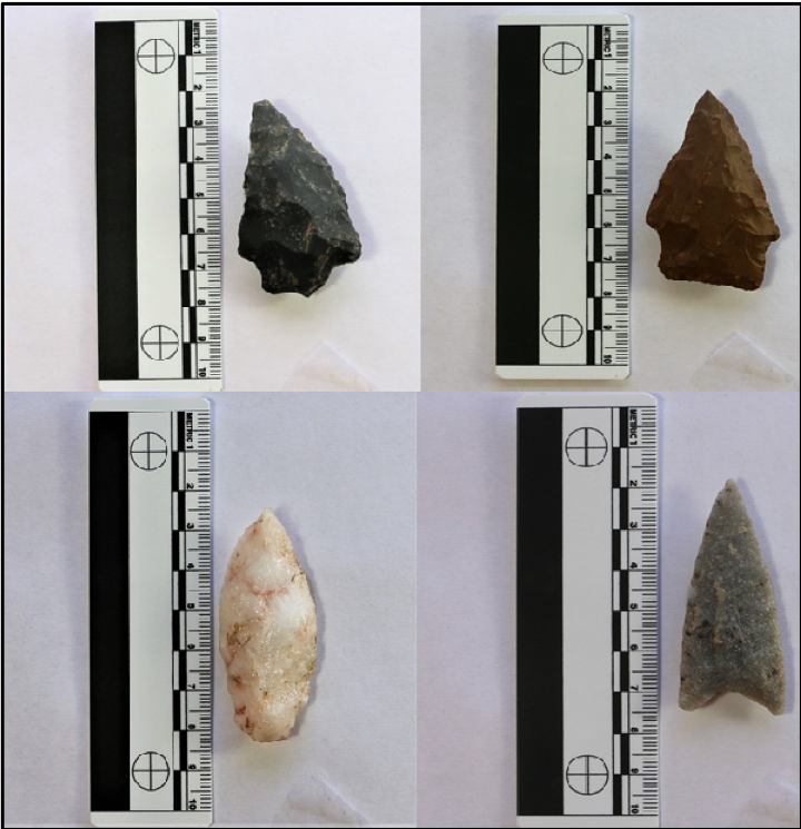
Figure 7: A collection of lithic artifacts made from chert (top), quartz (bottom left) and quartzite (bottom right).
Though the lithic artifacts of the Lower Dabbs site directly contrast what had been observed by Goad (1979), their preference for chert may be explainable. One possible explanation is that the people of the Middle Woodland period recognized the difficulty in working quartz as opposed to chert, and therefore spent little time trying to create tools from quartz. Due to their location on the river, these people likely had access to both chert and quartz, but it would appear that chert was the preferred material. As is noted in the lithics book by William Andrefsky Jr, chert is one of a select types of stone that can be manipulated to crack or break in a certain way, while the breaking of a quartz stone may be much harder to predict (Andrefsky Jr 2005, 24). This would also be apparent in the large quantity of incomplete and broken quartz points recovered. However, there were certain cases in which well-made quartz artifacts were recovered from the site and analyzed.
Finally, I wanted to analyze the different types of chert used to make the majority of the points found at the site. When analysis began, a wide variety of colors were present in the chert used to make the points. In addition to the colors, the quality of chert analyzed also differed. There were some artifacts that appeared to be made of high quality chert, and others were of what appeared to be a lower quality. When my research began, I was under the belief that the different colors of chert meant that these were all different types of chert, leading me to believe that this definitively proved that trade was occurring at the site. Further, more detailed analysis showed that this may not be the case. For this portion to be done, I analyzed and researched all of the chert materials as a whole from the assemblage that had been recovered from features, and then grouped similar artifacts together to compare and contrast.
It is here that the work by Sharon Goad proved to be most useful, as her investigation into materials used by prehistoric Native Americans is one of the most detailed chert study in the region and is regarded in multiple reports as such. The Lower Dabbs site is located in a geological region of Georgia known as the Ridge and Valley region, and more specifically the Great Valley region. As mentioned by Goad, chert was less common in this area as it was in the Northwest corridor of the state, and that most groups in this region would have been using quartz and quartzite (Goad 1979, 16).
This led me to question why so many artifacts were made of chert, and if this overwhelming presence of chert-made artifacts could indeed suggest that the inhabitants of this site were trading with other groups. As mentioned in a report by Jerald Ledbetter, Lisa D. O’Steen and Scott Jones (2009), while local chert sources in this region were typically used by people of the Archaic people, higher quality chert was used by groups from later time periods (such as the Woodland and Mississippian) and was often imported from more distant sources (Ledbetter, O’Steen and Jones 2009, 37). This further fueled belief that the differences in chert used to make the points would have implied trade.
While trading is known to have occurred during the Middle Woodland time period and thereby cannot be disproven, consultation with a geological map of the region as well as cross checking with the Goad book revealed interesting findings. First, the geological map showed that the Lower Dabbs site is located on a hotspot of chert known as Knox Group chert. In addition to this map, a report of the local Hardin Bridge site also included a photograph of a large outcrop of chert that was also determined to be Knox Group (Epenshade and Patch 2008, 9). In her work, Goad explains how Knox Group chert is divided into three other types: Copper Ridge, Chepultepec, and Longview. The most common of these for toolmaking is Copper Ridge, and is also known to be found in a wide variety of colors (Goad 1979, 15). Goad further noted forms such as chepultepec were less desirable for making tools, as they are of a poorer quality and are sometimes described as appearing to be “worm-eaten” (Goad 1979, 15). This characteristic resembles the pores commonly found on sponges, and was in many instances observed on the materials recovered from the Lower Dabbs site.
Certain artifacts were made of a chert that was jet black in color. This dark color is known to be associated with a different group of chert called Fort Payne chert. While again present in the Ridge and Valley region, this type of chert was commonly to be found closer to the Northwest area of the region. As mentioned in the report by Goad, Knox and Fort Payne chert were the two most common types used for toolmaking in the Ridge and Valley region (Goad 1979, 18). The Fort Payne material was originally believed to be non-local. However, after again reviewing the geological map, I found that this material is locally found in Polk County (which is the county directly south of Bartow County where the Lower Dabbs site is located).
One of the completed Yadkin points was determined to be made from quartzite, which was thought only be available near the coasts and would again suggest trading. Final consultation with the geology map proved that quartzite is also locally available and can be found near Lake Allatoona. While there is no proof or evidence to say that trade did or did not occur at this site, the argument can now be proposed that there is enough local material to prove that these points could have all been made locally.
Conclusions
While this research addressed numerous aspects of lithic analysis, there are other aspects that could be further investigated if this research were to continue. Most of this research was conducted with an emphasis on the complete and incomplete artifacts that could be typed. While these artifacts were successfully used to date the site, some of the artifacts that were pulled for this research were left untouched. Such artifacts include the flake tools, incomplete tools, preforms, and shale/slate tools. In most cases, flake tools were flakes that had small portions of one side worked into what could maybe be used as a small blade or scraper. Interestingly, however, one of the flakes was actually worked into what appeared to be a point.
Though most of the incomplete tools were left unanalyzed because they lacked a base in order to be typed, later review found that some of these may have been intentionally made without bases and were not meant to be points in the first place.
Shale/slate tools received little attention due to the lack of material and fact that all of them incomplete. Further research could potentially investigate how shale and slate overall may have been used to create specific artifacts at prehistoric sites.
Finally, in terms of source materials and rocks used to make the points, later research may warrant spending some time in the field looking to see just how locally available some of these materials are. It is believed that there is a nearby chert outcrop on the far side of the site near the river, but in general exploring up and down river could potentially reveal a wide variety of materials.
This research was the first of its kind to be performed at the Lower Dabbs site, as to date no other lithic analysis has been conducted. By performing my research, I was able to answer multiple questions, while also raising new ones. By typing and dating the points that came from Feature 120 and combining this new information with what is known of the ceramics and charcoal samples in the same feature, a Middle Woodland occupation of the site was confirmed. Additionally, learning and understanding the known trends in lithic technology of the Middle Woodland period, as well as the periods before and after, helped to show that the majority of typed artifacts were also from the Middle Woodland. Through understanding the Archaic style points recovered, I was able to speculate that there may also have been activity in the area before the main occupation at the site. Understanding the different materials used to create the tools that were excavated allowed for new questions to be raised about whether or not there was trade occurring. By discovering that there are local sources in which these materials could have come from, lithic analysis alone may not be enough to confirm nor deny trade. Going further, this research may even help researchers not only to understand trends in lithic artifacts from this site, but also trends in lithics from the region as a whole. Lithic analysis is just one of many skills required to give a complete understanding of the prehistory of Georgia.
Acknowledgements
I would first like to thank my advising professor and mentor, Dr. Terry Powis, for overseeing this project and for providing me with all of the resources, educational assistance, research tools, and other advising necessary throughout this research. None of this could have been done without his assistance contributions. I would next like to thank Andy Dabbs, owner of the land and namesake for the site, for allowing myself and other students to excavate the site on his land and do research on the artifacts recovered. I would also like to thank Patrick Severts for allowing me to use his photography setup in order to take high quality images of the artifacts. I would like to thank my Family for their support in all of my endeavors in anthropology and archaeology, and for them taking interest in my field knowing my passion towards this work. Finally, many steps of the recovery phase and cataloging were time consuming, but made shorter with the help of friends and fellow students in the anthropology department. It is here that I would like to mention and thank these individuals for taking the time to help me with some of this labor: Gary Owenby, Ellie Stanley, Anne Marie Butz, Danielle McClarty, and other students who contributed throughout the semester.
Appendices
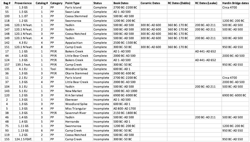
Appendix A: Measurements and data for all complete artifacts recovered from the site.
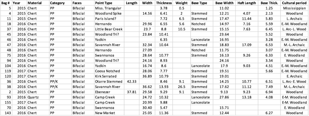
Appendix B: Dates of typed points (complete and incomplete) recovered from the site.
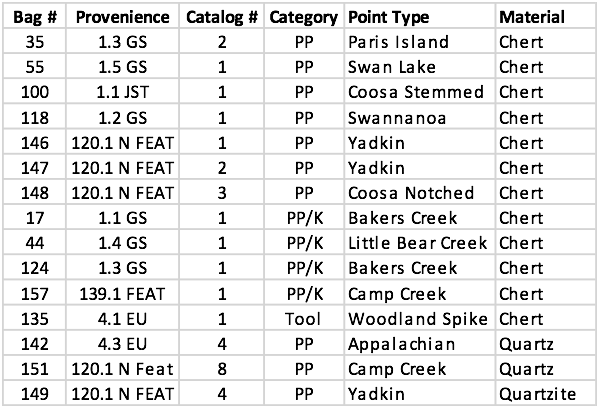
Appendix C: Materials used to make the complete points analyzed from the site.
Appendix D: Measurements and data for all typed incomplete points.
References Cited
Andrefsky Jr., William. 2005. Lithics: Macroscopic Approaches to Analysis. Cambridge: Cambridge University Press.
Espenshade, Christopher T. and Shawn M. Patch. 2008. A Middle Woodland Household on the Etowah River: Archaeological Investigations of the Hardin Bridge Site, 9BR34. New South Associates.
Goad, Sharon I. 1979. Chert Resources in Georgia: Archaeological and Geological Perspectives. Athens: University of Georgia.
Hudson, Charles. 1979. The Southeastern Indians. The University of Tennessee Press: Knoxville.
Ledbetter, Jerald, Lisa D. O’Steen and Scott Jones. 2009. The Late Archaic to Early Woodland Transition in Northwest Georgia: Evidence for the Terminal Archaic (ca. 1100- 600 B.C.) Period Occupation in the Region. Southeastern Archaeological Services, Inc.
Keith, Scot J. 2010. Archaeological Data Recovery at the Leake Site, Bartow County, Georgia. New South Associates.
Peach State Archaeological Society. 2018. “Projectile Points”. http://www.peachstatearchaeologicalsociety.org/index.php/2-uncategorised/344-projectile-points
Projectile Point Identification Guide. n.d. “Projectile Points of Georgia”. http://www.projectilepoints.net/Search/Georgia_Search.html
Whatley, John S. 2002. “An Overview of Georgia Projectile Points and Selected Cutting Tools” Early Georgia 30 (1): 1-133.
Wood, Dean W. and William R. Bowen. 1995. “Woodland Period Archaeology of Northern Georgia” University of Georgia Laboratory of Archaeology Series 33 (9): 1-23.
