In the previous installment, the history of the discovery and documentation of the Leake site was presented. In this installment, we examine the earthworks at Leake. While the earthen mounds at Leake are no longer visible on the ground surface, as are those at the spectacular Etowah Mounds located a few miles upriver, there were formerly three large mounds at Leake. Although the above-ground portions of these mounds were razed away in the mid-1940s as part of the Highway 113 reconstruction, the lower portions of these are still present under the modern ground surface. In addition to the mounds, there appears to have been a very large ditch enclosure at the site, similar to the one still visible at Etowah Mounds. In this article, I describe what is known about each of these earthworks based on the archival record and the archaeology conducted at the site.
Between 1938 and 1943, the Dallas-Rockmart Highway, currently known as Highway 113, was relocated from its former course closer to the river to the northwest to its present course, which happens to be directly over Mound B. The aerial photographs taken by the Agricultural Stabilization and Conservation Service in 1938 and 1943 provide some information about the impacts to the mounds (Figures 1 and 2). As discussed in the previous article, the signature of Mound B in the 1943 photograph is no longer indicative of trees, but rather of open ground, indicating that the above-ground portion of this mound had been removed. Mound A displays a similar signature to the 1938 aerial photograph, suggesting that it may not have been razed by the time of this photograph. Mound C is visible as an open area, suggesting that it was razed as part of the road building activity. The ditch feature visible in the 1938 photograph is largely indiscernible in the 1943 photograph. While it is extremely unfortunate that these mounds were razed and used as fill for the new road embankment at that time, fortunately the lower portion of at least Mounds A and B and the ditch are still present, as demonstrated by several different investigations of the site since the time of the road relocation.
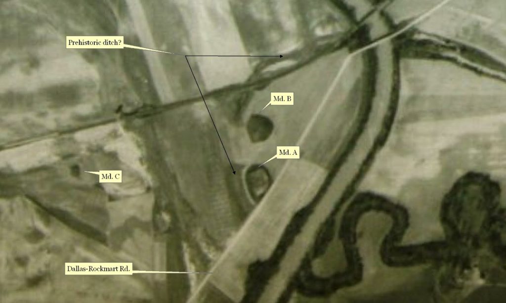
Figure 1. 1938 Aerial Photograph Showing the Leake Mounds (Agricultural Stabilization and Conservation Service 1938)
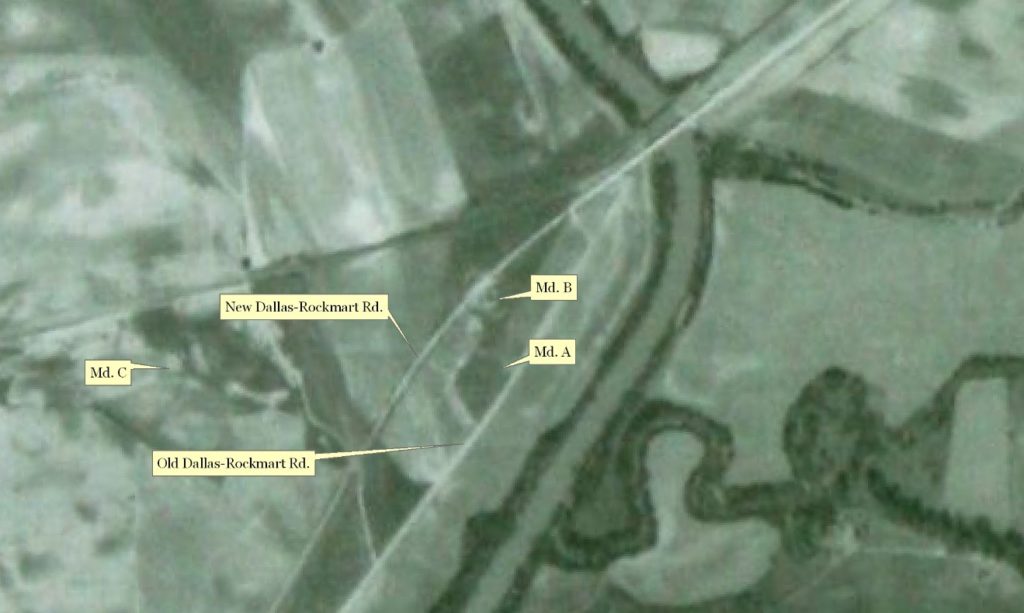
Figure 2. 1943 Aerial Photograph Showing the Leake Mounds (Agricultural Stabilization and Conservation Service 1943)
Mound A
Mound A was included in each of the maps of Leake drawn by Smithsonian Institution archaeologists John Rogan (see here) and James Middleton (see here) in 1883. Rogan (1883) described Mound A as a loaf-shaped mound measuring 300’ (N-S) by 200’ (E-W), but he did not provide a height, while Middleton (1883) described it as seven feet high and 150’ square. Importantly however, Middleton described is as “flat topped”. Archaeologists refer to such flat-topped mounds as “platform mounds”, and believe that during this period of time, their flat summits were likely used as stages for public rituals and displays, as opposed to built structures such as a house.
Dr. David Hally of the University of Georgia conducted archaeological field school excavations at Leake over three seasons, from 1988 through 1990, focusing on the Mound A area due to the presence of a Late Mississippian period (circa 1400-1550 A.D.) village (Figure 3). A portion of his excavation was conducted within Mound A. The investigators found evidence that three mound construction stages were still intact. Carbon samples from three features in the mound (see Figure 4, right) were radiocarbon dated, ranging in age circa 200-550 A.D., indicating that this portion of the mound and the features within it date to the Middle Woodland period. It is important to remember that the upper portion of the mound was razed away circa 1940, so archaeologists cannot know precisely how long it continued to be added on to or used in some manner, but based on their excavations, the investigators felt that the Late Mississippian people may have done so (Hally 1989, 1990a, 1990b; Rudolph 1989, 1990).
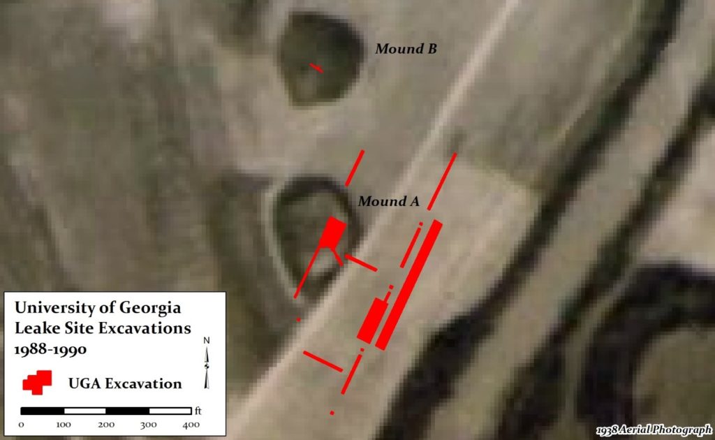
Figure 3. Map showing location of University of Georgia Excavations at the Leake Site, 1988-1990.
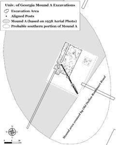
Figure 4. Maps of UGA Excavations within Mound A. Left: Plan Map showing location of line of posts. Right: Map of features encountered during the excavation. Note that radiocarbon dates were acquired for samples from three of these features, ranging from circa 200-600 A.D.
As Figure 4 shows, the excavation within this area of Mound A uncovered many features, including postmolds and pits. In addition to uncovering approximately 75 pit features, they also identified a straight line of postmolds within the mound that extended for at least 75 feet. On one slope of the mound, they found a thin lens of dark midden soil that contained burned bones, lithic artifacts, and pottery, including a large portion of a Swift Creek vessel (Rudolph 1989).
Mound A has not been excavated since the UGA field school excavations. The northern portion of Mound A is under private ownership and lay beneath a graveled parking lot. However, the southern portion lay on Bartow County property, and with their approval, archaeologists with the Georgia Department of Transportation and the author conducted a Ground Penetrating Radar (GPR) survey of the Mound A area in recent years (Figure 5). GPR is a non-intrusive technology that allows archaeologists a view of the soil conditions under the ground surface via radar pulses into the subsurface. Archaeologists closely examine the GPR data to determine if the subsurface signatures observable in the data might represent archaeological features that were created as a result of past human activity. On Mound A, we found possible evidence for the presence of more than one mound stage, as well as the old course of the highway that truncated the southern end of the mound (Baughman and Keith 2014).
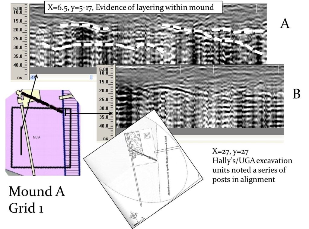
Figure 5. GPR in the Mound A area (Baughman and Keith 2014:100 Figure 10).
Mound B
Mound B was described by Middleton (1883) as “small, conical, about five feet high and seventy-five feet in diameter…seventy-five yards north of No. 1” (which is now known as Mound A). Whereas the other descriptions of Mound B, including his co-worker Rogan’s, indicate that it once stood anywhere from 14 to 18 feet above the surrounding ground level, Middleton (1883) states that it was five feet tall. We do not know what accounts for the difference in these measurements, but it may be that Middleton was measuring the portion of the conical mound that was steepest on the presumption that the rest of the mound was simply part of a natural, elevated landform. The only known photograph of the mound (see the first article in this series for further description of this photograph) suggests that it was between 14 and 18 feet in height, based on the trees growing upon it (Figure 6).
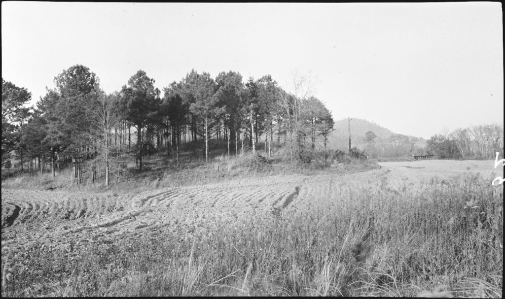
Figure 6. 1917 Photograph of Mound B (Anonymous 1917). Original caption reads: “Indian Mound on Leake Property, 4 Mi. S.W. of Cartersville”.
Because mounds had been largely razed during old road relocation circa 1940, the precise boundaries of Mound B were unknown prior to the data recovery investigation, when the 1938 aerial photographs that showed the mounds were discovered. Rogan (1883) reported excavating a trench into one of the mounds (probably Mound B) from “south to north”, extending from the top of the mound to the “natural soil on which it was resting”. There is a discrepancy between Rogan’s written description of the soil profile of the mound that he trenched and the drawn soil profile, observable in Figure 7, which is included with his notes. Rogan’s (1883) textual description is as follows:
“First on top a 6 inch layer of dark rich soil; then a round fire basin 12 inch deep and 24 inches in diameter. This basin was simply clay hardened by fire to about the thickness of an inch. It was full of charcoal and ashes. The plow had knocked off part of the edges and in trying to get it out it broke into so many fragments that I could not save it. Just immediately below this basin was a 12 inch layer of very bright red clay; then 2 feet 6 inch layer composed of a mixture of red clay, dark mulatto soil, with a large quantity of charcoal and ashes intermingling. These materials were evidently thrown inot this layer in quantities ranging from a peck to a half bushel, but they so intermingled with each other that it was impossible to make a drawing showing just where one color ended and the other commenced. Next below this was a 6 inch layer of pure white sand – such as is found on regular sand bars and last at the bottom of the mound was layer of [prarier]? soil 1 foot 6 inches deep.”
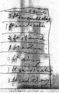
Figure 7. Rogan’s (1883) sketched soil profile for Mound B
In adding up the depths of the strata within each soil profile, the textual description adds up to seven feet in depth, while the sketched soil profile (see Figure 7) adds up to 15 feet. Is it possible that Rogan excavated into both mounds? His colleague James Middleton (1883) documented Mound A as seven feet in height, and Mound B as only five feet in height; Rogan (1883) does not provide a height for Mound A, but describes Mound B as 15 feet in height. Rogan makes no mention in his notes of excavating into two mounds.
Over 100 years after Rogan and Middleton came to investigate the Leake site, Dr. David Hally and Jim Rudolph of UGA conducted archaeological excavations through University of Georgia field schools. While they focused their primary effort in the area of Mound A, they also excavated several trenches within Mound B. Similar to their work at Mound A, they found that the lower portion was present under the ground surface (Hally 1989, 1990a, 1990b; Rudolph 1989, 1990). Intact portions of the mound were identified on the northwest side of the highway during the archaeological testing work for the highway widening conducted in the late 1990s (Pluckhahn 1998).
During the data recovery excavation in advance of the relocation of the water line due to the road widening, the excavation extended into the southwestern side of the mound (see Figure 8 below), revealing several interesting aspects of the mound (Keith 2010). The map in Figure 8 below shows the excavation block trenches and blocks with the mound, while the black numbered dots represent postmold features. Observable on the right, or eastern, side of the trench is a linear row of post features arranged roughly north-south (Figures 8 and 9). These posts were spaced at regular intervals, and all were similar in size and soil fill (see Figure 9).
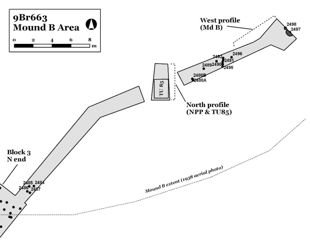
Figure 8. Map showing excavations in Mound B (Keith 2010:139 Figure 142).

Figure 9. Linear row of postmolds in base of Mound B (Keith 2010).
Further east from this line of posts, along the eastern end of the excavation trench, was a very large post feature (Feature 2497), and a small burned post feature (Feature 2498), which are observable in Figures 8 and 10. We obtained a radiocarbon date from the charcoal in the burned post Feature 2498, which returned a 2-sigma calibrated date of 383 – 122 BC, with a mean date of 270 BC. Beside this small post, Feature 2497 was an extremely large post – approximately 24-30 inches in diameter – that extended down through the dark artifact-rich midden soil of the former ground surface. At some point in the first century BC, the midden appears to have been leveled in some places, the large post was removed, and a homogenous brown silty clay loam – devoid of artifacts – was lain down to at least a thickness of three feet to form a mound. Unfortunately, the portions of the mound above this initial mound stage were removed, so we do not know its entire constructional sequence, apart from the conflicting soil descriptions provided by Rogan (1883).
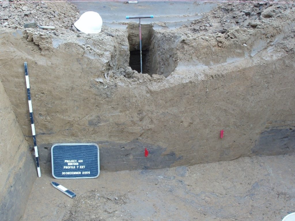
Figure 10. Photograph of eastern end of trench. Existing waterline along River Court SW running parallel to this trench wall is marked by blue-handled probe. Feature 2498 is the small dark soil stain marked by the red flag on the left, while the center of the large post feature, Feature 2497, is marked by the red flag on the right. The dark soil lens in the trench profile is a midden, while the homogenous brown soil atop it and in the hole left by the removal of the large post in Feature 2497 is believed to be the first stage of Mound B. Note that remnants of the midden ring the large post feature from when it was extracted.

Figure 11. Photograph of soil profile within Mound B. Note that the red flag marking Feature 2498 is located in the lower right corner of the frame. A slope of the mound is visible, rising from the left of the frame toward the right, running under the upper-most black stripe on the scale marker (which is 1 meter in length). Slope wash from the now-absent portion of the mound upslope is present atop this initial mound fill stage. The dark spot visible about 20 centimeters left of the scale marker was a chunk of charcoal that returned a radiocarbon date range of 347-02 B.C, with a mean date of 128 B.C.
While Mound B was a conical mound, no Middle Woodland period burials have been found within it. This is somewhat unusual because most conical-shaped mounds constructed at this time served as burial mounds. Rogan (1883) stated clearly that he found “nothing at all” in the mound during his excavation. However, a Mississippian period burial was identified within this mound during the testing investigation (Pluckhahn 1998). In consultation with Native American tribal authorities as part of the highway widening and bridge replacement project, the GDOT ensured that the remaining portions of this mound were carefully buried in fill so that it would be protected from road construction disturbance.
Mound C
Very little is known about this mound. Middleton (1883) provides the only known description of it, stating that is was “small, circular, flat topped…seventy five feet in diameter and eight feet high” (Middleton 1883:6). Robert Wauchope, an archaeologist who recorded many sites in northern Georgia during the late 1930s and then revisited many of the sites 20 years later in the late 1950s, wrote that he “could not even find it during the summer visit in 1957” (Wauchope 1966:238). Perhaps because it was located relatively far from Mounds A and B, one quarter mile to the west, for years the precise location of this mound was unknown, but the discovery of the Rogan and Middleton maps helped in determining its likely location (Keith 2010). Specifically, their sketch maps of the Leake site were georeferenced by comparing them with early aerial photographs and topographic maps, helping to “rubber sheet” them onto the modern ground surface (Figure 11). While it is presumed that Mound C dates to the Middle Woodland period like Mounds A and B, this has not been established. No on-the-ground work has been conducted to determine what may remain of this mound, but it appears that the northern half is likely destroyed due to the construction of a building and access road atop it.
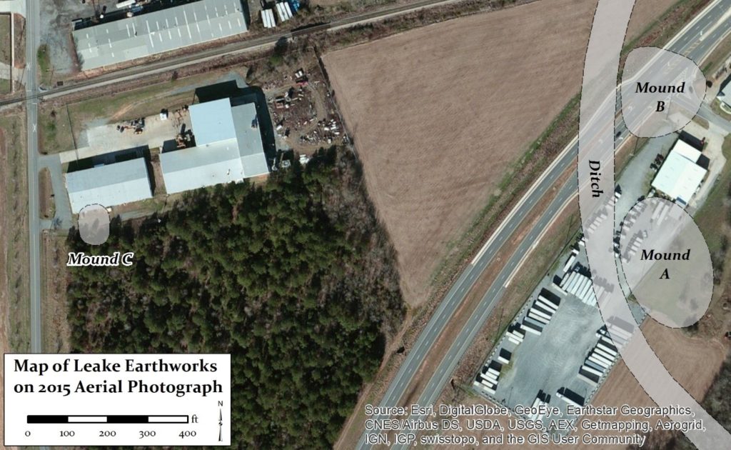
Figure 12. Leake Site earthworks and modern development.
Ditch enclosure
One of the most significant archaeological features of the Leake site which was identified as a result of the large data recovery excavation is a semi-circular ditch enclosure (Figure 13). This massive earthwork feature was not noted nor described by the Smithsonian researchers in the late 1800s, as it is not visible on the modern ground surface with the naked eye. Rather, this ditch feature was recognized as such during the data recovery when a large section of it was uncovered, in combination with a careful review of the evidence for it in the data from the numerous other excavations of the site (Hally 2007 personal communication, 2008 personal communication; Pluckhahn 1998; Southerlin 2002; Southerlin et al. 2003), along with its signature in historic aerial photography (Keith 2010). While we do not have excavation data for the entire length that would provide its exact path, the available data suggest that it extends from the area of the Highway 113 bridge, arcs around the western sides of Mounds A and B, and ends at the river southeast of Mound A (Figure 13). It is unknown if the ends were open to the river, but there is evidence that water was present in at least a portion of ditch.
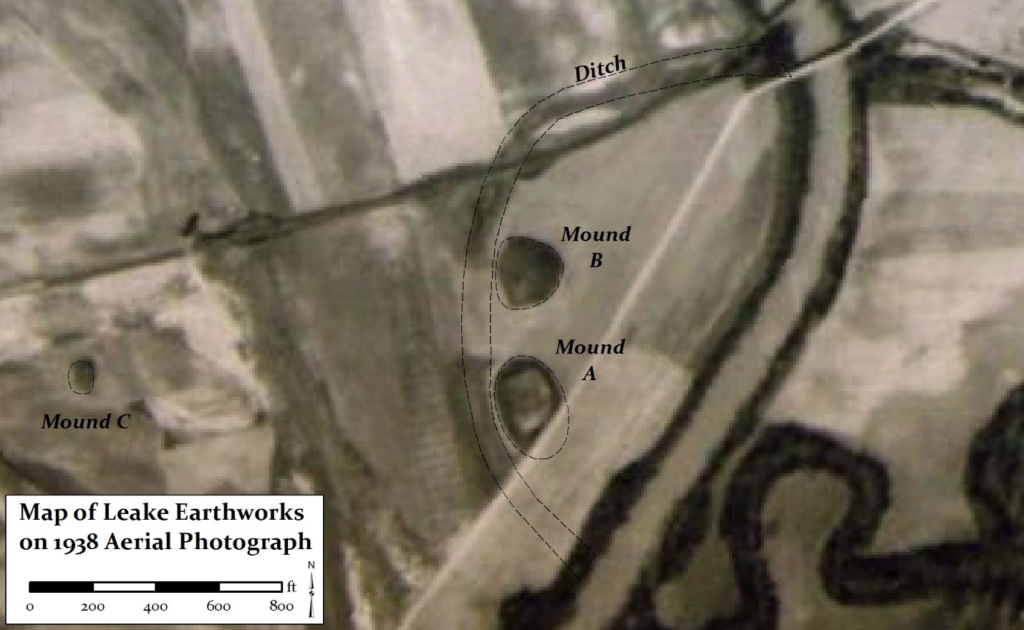
Figure 13. Leake Earthworks on 1938 aerial photograph.
Portions of the ditch that were exposed and investigated during the data recovery measured approximately 45 feet in width and at least 5.5 feet in depth, although the bottom was not reached during excavations due to safety issues (Keith 2010). The map in Figure 14 depicts the location of the ditch (symbolized by the gray area in the figure) within a large excavation area; much of this area is currently under the parking lot of the trucking company that occupies this location. The two narrow branches of the ditch observable just left of the “Feature 2026” label are believed to represent old erosional gullies that formed along the edge of the ditch.
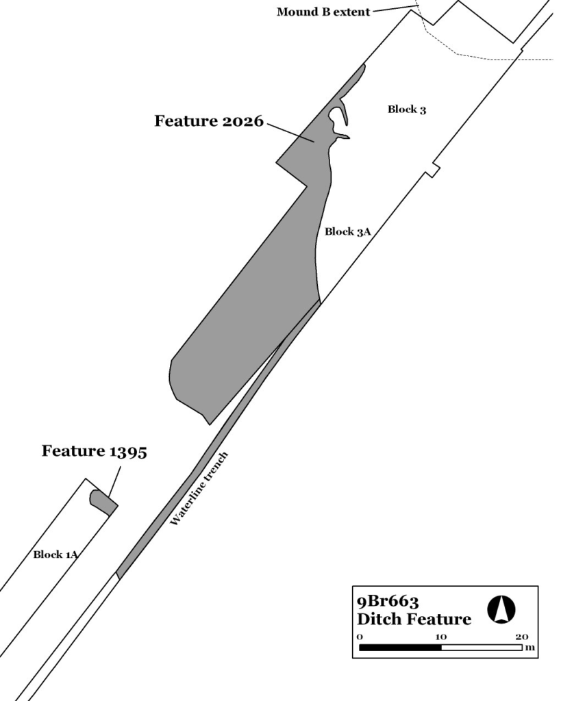
Figure 14. Map showing location of ditch feature in the area south of Mound B (Keith 2010:111 Figure 109).
As observable in Figures 15 and 16, the ditch consists of dark, organic soil. If the ditch was a prominent earthwork at Leake, one question that arises is why it was not noted or depicted by the early investigators of the site. The most plausible explanation at this time is that this massive feature simply filled in from centuries of river flooding, particularly if it was open to the river at one time. Test units placed in the ditch fill revealed that the artifacts are mixed and jumbled in terms of their age and stratigraphic positioning, indicating that they were likely deposited by flooding as opposed to activities taking place in those test unit locations.

Figure 15. Photograph facing south along a trench excavated to inspect the ditch.
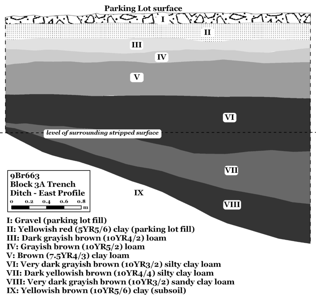
Figure 16. Soil profile of the ditch in the area south of Mound B (Keith 2010:115 Figure 116)
The ditch at Leake is similar to the one still visible at the Etowah Mounds just upstream. At Etowah, Smithsonian archaeologist Rogan (1883) felt that at least the western end of the ditch was originally open to the river, but had later been filled in by the landowner to prevent it from filling with water. Both Rogan and antiquarian C.C. Jones (1861) believed that Etowah ditch was originally open to the river, and thus placed the mounds on an island. At Leake, the shape and path of the ditch suggest it may have extended continuously to join the river on both ends, which would also have enclosed Mounds A and B on a human-made “island”. Ditch features are like these are relatively rare at Middle Woodland period sites in the Southeastern US. At the Middle Woodland Fort Center site in peninsular Florida, Sears et al. (1982) recorded a series of mounds and earthworks, including a 365-meter-diameter semi-circular ditch, each end of which connected to the river. Middle Woodland researchers generally believe that ditches and other earthwork enclosures were used at sites like Leake to create and segregate sacred and ritual spaces.
The GPR survey of portions of the site provided information on portions of the ditch in the area south of Mound A, and also on the north side of the highway. The GPR survey helped to confirm the presence of the ditch in areas where it was hypothesized to occur but where there are no data from excavations. Interestingly, the GPR data suggests that the course of the ditch in the area south and east of Mound A is several meters further north than hypothesized, and perhaps even more interestingly, that there may be evidence of an earthen embankment ringing this ditch enclosure (Baughman and Keith 2014).
While the impressive earthworks at the Leake site have been negatively impacted over the last two hundred years as the area was settled and developed, they fortunately have not been destroyed altogether. As the discussion above demonstrates, significant portions of these features remain under the modern ground surface, invisible to the naked eye. Archaeological investigations and archival research have yielded much information concerning when and how these monumental earthworks were built and used. Investigation of these earthworks is ongoing, and will be greatly facilitated by the use of non-invasive remote sensing techniques such as Ground Penetrating Radar that offer excellent opportunities for examining the archaeological record without having to conduct excavations that are more expensive, time-consuming, and by their very nature, archaeologically destructive.
References Cited
Baughman, Pamela and Scot Keith
2014 Ground-penetrating Radar at the Leake Site: Investigations, Results, and Interpretations. Early Georgia 42(2):123-141.
Hally, David J.
1989 Excavations at the Leake Site. LAMAR Briefs 13:6.
1990a The Leake Site (9Br2). LAMAR Briefs 15:4-5.
1990b Leake Site Excavations. LAMAR Briefs 16:1.
Jones, Charles Colcock. Jr.
1861 Monumental Remains of Georgia, Pt. 1. John M. Cooper and Co., Savannah, Georgia.
Middleton, James D.
1883 Material Concerning the Archaeology of Bartow County, Georgia. Manuscript 2400, Box 2, Georgia, Smithsonian Institution National Anthropological Archives, Smithsonian Museum Support Center, Suitland, Maryland.
Rogan, John P.
1883 Notes on Mounds in Georgia. Inventory of the George E. Stuart Collection of Archaeological and Other Materials, 1733-2006, Collection Number 5268, Wilson Library, University of North Carolina, Chapel Hill.
Rudolph, James L.
1989 1989 Excavations of Mound A at the Leake Site (9Br2). LAMAR Briefs 14:4-5.
1990 Letter to James B. Langford, cc to Dave Hally, Dean Wood, Pat Garrow, and Woody Williams. Provided to the author by Jim Rudolph.
Sears, William H., Elsie O’R. Sears, and Karl T. Steinen
1982 Fort Center: An Archaeological Site in the Lake Okeechobee Basin. University Press of Florida, Tallahassee.
Southerlin, Bobby G.
2002 Archaeological Evaluation of the 84 Lumber Tract, Cartersville, Georgia. Submitted to 84 Lumber Company, Eighty-Four, Pennsylvania, by Brockington and Associates, Inc., Atlanta, Georgia.
Southerlin, Bobby, Julie Wilburn Peeler, Dawn Reid, and Rachel Tibbetts
2003 Archaeological Evaluation of the Rockmart Highway Water System Improvements, Bartow County, Georgia. Prepared by Brockington and Associates, Inc., Atlanta for the Bartow County Water Department, Cartersville, Georgia.
Wauchope, Robert
1966 Archaeological Survey of Northern Georgia: With a Test of Some Cultural Hypotheses. Memoirs of The Society for American Archaeology, Number 21. University of Utah Printing Service, Salt Lake City, Utah.

