An Architectural Analysis of Native American Houses
During the Middle Mississippian Period in the Etowah River Valley
By Jordan Farkas
ANTH 3397
Practicum in Anthropology
Department of Geography and Anthropology
Kennesaw State University
Kennesaw, Georgia
May 12, 2021
Abstract
The Mississippian period lasted from AD 1000-1550. It is divided into three different subperiods: Early (AD 1000-1200), Middle (AD 1200-1375), and Late (AD 1375-1550). Mississippian life, in general, is characterized by a chiefdom form of political organization, large villages located on floodplains near major rivers, single-set post and wall trenched houses, and a subsistence base centered on corn or maize agriculture. Material culture included plain and decorated pottery and triangular-shaped projectile points.
The Middle Mississippian is distinct from the Early Mississippian and Late Mississippian subperiods due mainly to changes in pottery (temper, thickness, form, and decorative motifs) as well as house design, shape, and construction practices. This research focuses on houses during the Middle Mississippian subperiod and how they compare and contrast with those found at both large and small sites. The research focuses on how they were constructed, where they were constructed, perceived differences in summer and winter houses, and what features were found associated with them. It will examine a single house that has been recently excavated at a small village known as the Cummings site located to the west of the City of Cartersville in Bartow County, Georgia. The Cummings house is compared to those found at Etowah dated to the same time period. Etowah was a large regional center located only three kilometers (two miles) to the southeast of Cummings. Both sites have a well-documented Middle Mississippian component which will allow for a fine-grained analysis of house types situated in the Etowah River Valley.
Introduction
This research looks at changes in houses in the Etowah River Valley during the Middle Mississippian subperiod. Specifically, it examines a single prehistoric Native American house that has recently been excavated at the Cummings site (named after the current landowner). The Cummings house is located on a high terrace above Pettit Creek approximately two miles (three kilometers) northwest of the Etowah Indian Mounds in Cartersville, Bartow County, Georgia (Figure 1).
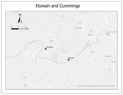
Figure 1. A map showing the location of the Cummings Site and the Etowah Indian
Mounds. Map courtesy of Bryan Moss.
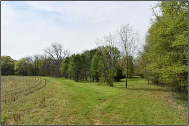
Cummings is the site used for an annual archaeology field school directed by Dr. Terry Powis of the Department of Geography and Anthropology at Kennesaw State University (KSU), Kennesaw, Georgia (Figure 2). For the past four years, investigations at Cummings have included Phase I Shovel Testing and Phase II Testing. It was through Phase II test excavations that the house was located. The house was completely excavated in the winter of 2021 as part of an anthropology practicum course. Less of a focus was placed on the material remains derived from the house floor than on the house shape, design, length of occupation, and construction methods used during the Middle Mississippian subperiod. The analysis of the house, located in a small village like Cummings, is compared to structures at Etowah, the largest site in the region. The intent is to use the comparative data to expose the relationship between large preeminent regional centers like Etowah and smaller sites like Cummings during the height of the Mississippian period.
Background
The Mississippian occupation of the Etowah River Valley spans from AD 1000-1550, when European contact was made between Spanish explorer Hernando DeSoto and the indigenous people living at Etowah. The Mississippian period is divided into three subperiods, Early (AD 1000-1200), Middle (AD 1200-1375), and Late (AD 1375-1550), with the height occurring during the middle subperiod. Mississippian life, in general, is characterized by a chiefdom form of political organization. In these systems, chiefs and their capitals hold religious and economic importance as well as political influence (King 2003). Chiefdom capitals are identifiable during this time by the presence of mounded architecture. Chiefly residences, temples, and other important civic and ceremonial structures were placed on top of these mounds. Large villages are characteristic during the Middle Mississippian, with a mixed subsistence strategy centered around maize agriculture. Other plants and terrestrial herbivores were also utilized. The Etowah River also provided abundant access to aquatic wildlife such as fish, shellfish, and waterfowl. Villages were located on floodplains along major rivers. This settlement pattern is significant as it provided nutrient-rich soil (due to periodic flooding) and therefore served as prime agricultural land to grow maize. The Etowah River Valley, in particular, is the most productive agricultural area in the Ridge and Valley Province, containing soils that are composed of weathered sandstone, shale, and limestone (Hally and Langford 1995).
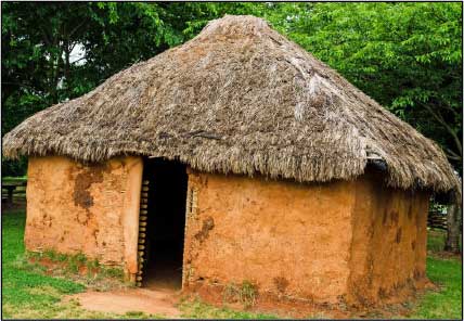
The Middle Mississippian is distinct from the Early Mississippian and Late Mississippian subperiods due mainly to changes in pottery and architectural practices. Decorative characteristics of pottery in the Etowah River Valley during this subperiod include thick-walled vessels with bold, curvilinear decorative motifs. Vessel forms include bowls, jars, dishes, and bottles. Wooden paddles with carved designs on them were used to create the decorative motifs found on the vessels. This was done by stamping the carved wooden designs on the pottery before they were completely dried. Houses, made using the wattle-and-daub technique, is the most common dwelling style used during this subperiod (Figure 3). Construction methods at this time shifted away from the wall-trench construction pattern used during the Early Mississippian period to a single-set post-wall construction. Therefore, after AD 1200 single-set post buildings became the dominant architectural form (King 2013). This construction method used large wooden posts pounded into the ground or set in pre-dug holes to form the framework of the house. Then smaller wooden limbs (such as rivercane) were used as wattle. The wattle is woven back and forth horizontally in between the upright posts to construct the house walls. These walls would then have been covered/packed in clay to provide insulation. Houses during the middle subperiod would have also been constructed using interior support posts. These interior support posts would have allowed and supported a hip roof design made out of thatch (e.g., long, thick grass). This differs from the early subperiod, whose houses lacked interior support posts and, as a result, had a bent-pole roof design. The Middle Mississippian period also saw a shift in house shape from rectangular, used during the Early and Late Mississippian subperiods, to a square shape with rounded corners.
Mounds. Photo courtesy of Terry G. Powis.
Methodology
The data collection for this research included a combination of both field and lab work. The fieldwork consisted of Phase III feature excavation. In order to fully expose the floor of the house, a total of 40 units were excavated. Each unit varied in size, with some measuring 1 x 1 meters, 1 x 2 meters, and 1 x 0.5 meters. All units were excavated using a square flat-bladed shovel, pointed round shovel, and a trowel. Each unit was dug in arbitrary levels of 10 cm. During the excavation of units, depth was maintained and controlled using a line level in reference to a master site datum. Soil excavated from each unit was screened through a ¼ inch mesh screen, where diagnostic artifacts such as pottery sherds, chert and quartz flakes, daub, FCR (fire-cracked rock), and projectile points/knives were collected. Artifacts recovered from each unit level were placed into a clear, plastic unit level bag, with the provenience information written on the front using a sharpie. The provenience information included the site name, quadrant number, unit number, feature number, date, and depth below unit datum.
Upon completion of each quadrant and unit, the north, south, east, and west wall profiles were recorded on graph paper to show the stratigraphy of the soil. Soil texture was recorded, along with the soil color, according to the Munsell Color system. Features were mapped along with any artifacts that were found on and around the house floor. Some of the items included pottery sherds, celts and burnt posts found in situ, fallen burnt posts, large concentrations of daub (clay applied to the walls of a house), lithic tools, and other artifacts of interest. The depth at which these mapped features and artifacts was recorded. After the entire house floor was exposed, it was also mapped. All artifacts were packaged in aluminum foil to be analyzed in the lab at a later date. Charcoal samples were collected in aluminum foil, taken from both the exterior and interior burnt posts found in situ. The charcoal samples were sent to the Center for Applied Isotope Studies (CAIS) at UGA for radiocarbon dating. Charred wood samples were also sent to archaeobotanist Leslie Raymer to determine the species of wood used in the house construction. Once the house was fully excavated, a trowel was used to scrape the floor. This was done to make sure the house floor was uniform across all quadrants and was the same depth. Photographs using a digital camera, video camera, and drone were taken. Photographs were taken of all of the in situ artifacts found on the house floor. General excavation photos were periodically taken to document the excavation process.
While the emphasis of the research was excavating the house floor, a limited ceramic analysis was performed in order to date the construction of the house. The analysis was conducted in the Anthropology Lab in the Department of Geography and Anthropology at KSU. It should be noted that a historic site dated to 1925, called the Adams Family House, is located adjacent to the Cummings site. As such, historic artifacts were occasionally found with prehistoric material in the excavation units. In the lab, the first priority was to separate the historic artifacts from the prehistoric. There were approximately 50 two-gallon Ziploc bags that needed to be sorted. The contents of each bag were placed on a tray, with diagnostic prehistoric artifacts, such as pottery sherds and projectile points/knives with an intact base, separated from the historic artifacts. Prehistoric pottery sherds were placed into one bag and any projectile points/knives into a separate bag, with both bags placed into a “parent” bag with provenience information written on the front. The same procedure was followed for the historic artifacts.
To accurately identify and type the pottery sherds and projectile points/knives, they first needed to be cleaned. Using a soft fiber toothbrush and a tub of water, all of the artifacts were cleaned and left to dry for at least a week. Once all of the artifacts were dry, decorated stamped pieces of pottery were separated from the plain ones, transferring the provenience information to the new bag. Decorated pottery sherds were typed using a flashlight and a high-powered microscope. Using Lloyd Schroder’s “A Field Guide To Southeastern Indian Pottery,” a total of 491 pottery sherds were placed into four different groups: Etowah, Savannah, Wilbanks, and Unanalyzable. Etowah was composed of three subgroups: Etowah Complicated Stamped, Etowah Brushed, and Etowah Simple Stamped. Savannah was composed of two subgroups: Savannah Check Stamped and Savannah Cord Marked. Wilbanks was only composed of Wilbanks Complicated Stamped. The Unanalyzable pottery group was composed of plain pottery, Lamar, Dunlap Fabric Impressed, Deptford Complicated Stamped, and Deptford Simple Stamped pottery sherds too small to comfortably type. Unfortunately, time ran out before an analysis of the 20 projectile points could be made.
Results
The results of the field and lab work indicate that the Cummings house dated to the Middle Mississippian subperiod. The size of the house measured 4.9 m (16 ft) east-west by 4.65 m (15.25 ft) north-south, or approximately 23 square meters (75 ft) (Figure 4).
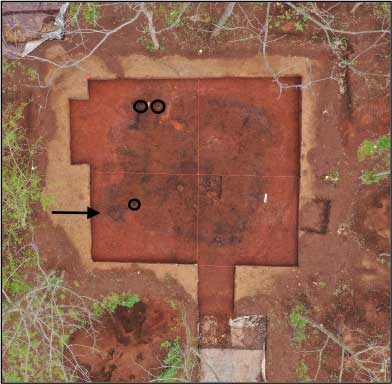
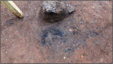
The height of the house is unknown but may have stood 2-3 meters (6.5-9.8 ft) high based on ethnohistoric accounts. The doorway or entrance into the house at Cummings is also unknown but there is a large enough gap between posts in the southwest area of the house to preliminarily state this was the original access point. Further work is needed to confirm this notion. Evidence on the excavated floor indicates that the house had burned down, which is demonstrated by the large concentrations of daub and the burned posts found in situ (Figure 5).
The shape of the house is square with rounded corners. It was constructed using a single-set post wall construction, with at least four interior support posts. The interior support posts supported a hip roof design. The house is oriented between 8°-18° east of north. An oval hearth is centrally located in the house and recessed in the floor. It measured about 50 cm in diameter, and has a depth of about 15-20 cm.
courtesy of Terry G. Powis.
Analysis of charred post samples from our archaeobotanist indicated the building material of both the exterior and interior posts was pine, most likely sourced locally. The radiocarbon date provided by the Center for Applied Isotope Studies (CAIS) at UGA gave a very narrow date range of AD 1260-1300 for the construction date of the house. This indicates that the house was built at the height of Etowah during the Middle Mississippian subperiod.
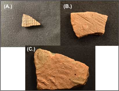
As was mentioned earlier, a total of 491 pottery sherds were examined. Eighty-six of these were successfully typed: seven were typed as Etowah Plain; five were typed as Etowah Complicated Stamped; one was typed as Etowah Brushed; and one was typed as Etowah Simple stamped. Thirty-nine pottery sherds were typed as Savannah. Thirty-eight sherds were typed as Savannah Check Stamped, and one was typed as Savannah Cord Marked. Forty sherds were typed as Wilbanks Complicated Stamped (Figure 6). The remaining 405 pottery sherds were typed as Unknown.
Other interesting artifacts excavated from the floor include two partial effigy pots, both of which seem to depict a bird/dog/deer on them. The base of a spittoon-style tobacco smoking pipe was excavated from around the hearth. A small broken ground stone spatula, possibly used for mixing food(s), and two greenstone celts were excavated from the northeast corner of the house (Figure 7).
Discussion
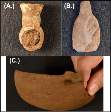
cooking spatula; (C.) shows one of the effigy pottery vessels possibly depicting a
bird’s face on it. Photos courtesy of Terry G. Powis.
Archaeological evidence such as the burned floor and posts, along with large concentrations of daub, indicates that the Cummings house had burned down. It is not clearly understood how this event unfolded, but there are possible cultural and natural phenomena that could explain it. The most likely natural cause is that the house was struck by lightning, causing the house to burn down. Culturally speaking, there are several possible explanations for the house’s destruction. One idea revolves around the notion that one of the occupants living in the house died and, as a result, the house might have been burned intentionally as part of a burial ceremony. Alternatively, a cooking accident at the hearth may have caused the house to burn down.
Another explanation is that the house might have been burned as a result of conflict or warfare. With villages in the valley reaching peak density during the Middle Mississippian subperiod conflict may have been inevitable given increased competition for land and resources. This may be tied to the political leaders at Etowah who may have had the occupants of this house, among others at Cummings, to vacate the area and move further away. This removal may have been an attempt by the leaders at Etowah to control the ever-growing population in the Etowah River Valley (Adam King, personal communication, 2021). If this was indeed the case, then perhaps the occupants living in the house at Cummings would have burned the house upon their departure from the area. The presence of artifacts on the burned floor of the house suggests that the occupants did not have much time to retrieve them once the fire consumed the house. It should be pointed out that the artifacts might have been purposefully left in situ as they were no longer needed wherever a new house was to be constructed.
The length of occupation for those living in the house at Cummings is currently unknown. Due to this research being preliminary and limited to only one excavated house, it is unclear whether this was a long-term or short-term occupation. During the Middle Mississippian subperiod, permanent occupation is associated with “paired winter and summer houses” (Lewis 2013). Both houses would have been situated very close to one another so that a single family could move easily between them when the seasons changed. Given that it took 4-5 months to excavate the floor, the seasonality of the house was the only thing not determined relating to the length of occupation. The presence of a hearth is used as one of the indicators of a winter house, and the absence of a hearth is used as one of the indicators of a summer house. A winter house is typically defined as having a central hearth used as the heating source during the cold months but also served as the cooking area. The number of walls is also another indicator of seasonality during this period, with winter houses being fully enclosed (with four walls) and being utilized during the colder months. The type of houses utilized during the warmer months would have been an “open-walled shelter suggesting (with only three walls) that it is a summer house or outdoor activity area” (Lewis 2013). Due to the presence of a central hearth, it is believed that the Cummings house was occupied during the winter months.
Due to the distribution and location of artifacts recovered from the floor, there does not appear to be any discernible activity areas or partitioning of space within the house. Of interest, most of the artifacts were found around the interior perimeter of the house, with very few found in close proximity to the hearth. However, a few artifacts have been recovered that give a general idea of some of the activities the occupants may have been engaged in. The stone celts, effigy vessels, and the broken tobacco smoking pipe suggest rituals may have occurred inside the house. The spatula and pottery vessels found on the floor may point to food preparation and storage. Cooking food inside a house at this time may have been fraught with problems – the main one being that embers could cause a fire inside the structure. Two styluses, or drawing implements, made from ground slate or andesite, along with pieces of galena and carved mica may indicate that the occupants were engaged in art-related activities. In areas where there were no artifacts may reflect where sleeping occurred. We have found no posts located near the house interior walls to indicate that benches were used for sleeping.
In terms of dating the house, there are two lines of evidence that securely date it to the middle subperiod. A single radiocarbon date of AD 1260-1300 provided by the Center for Applied Isotope Studies at UGA, as well as the typing of 86 sherds combine to provide an accurate temporal assessment of when the house was occupied. For the dating of the ceramics, a reliance on changes over time in decorative motifs, was utilized. However, it should be pointed out that while analyzing sherds identified as Etowah, Savannah, and Wilbanks Complicated Stamped types it became evident that there are no real recognized decorative differences between the three types. Today, archaeologists who work with the Middle Mississippian subperiod do not recognize differences between Etowah, Savannah, and Wilbanks ceramic types. This is because when they were initially identified in the 1950s there were personal relationship issues between the principal investigators conducting research in north Georgia, which resulted in the same decorative stamp being labelled as three different types. Therefore, everything that has a curvilinear stamped design is now typed as Wilbanks Complicated Stamped.
Archaeobotanist Leslie Raymer indicated that the building material used for the exterior and interior posts was pine wood. However, the horizontal building material used for the woven material (wattle) in between the exterior posts is still unknown. None of this building material was excavated, and it is likely that none of it survived when the house was burned down. It is believed that this material most likely would have been river cane. This would have been very easily sourced from along the banks of Pettit Creek and/or the Etowah River. The clay walls of the house would have been smoothed with a maximum thickness of about 15 cm. The material used for the roof is also unknown at this time but most likely would have been constructed using thatch. This type of roofing material would have needed constant upkeep as any holes or leaks in the roof appeared. It may have also needed to be periodically replaced as it was also common for these roofs to become infested with bugs and other insects.
Conclusions
In sum, the Cummings house is a square, single-set post construction with rounded corners that measures 4.9 m east-west by 4.65 m north-south, covering 23 square meters (75 sq ft). Our investigations indicate that, based on the house excavated at Etowah, the house at Cummings appears to be domestic in nature. Importantly, the size and shape of the Cummings house mirrors that at Etowah, which King (2001) labelled as a “square, single-set post building with rounded corners that measured 15 feet on a side”. The inhabitants living in the house that Adam King refers to is perceived as high status due to “their location adjacent to Mound B” and that the “inhabitants may have been of elevated status” (King 2001). Were the inhabitants of the house at Cummings of similar high status to those at Etowah or is the size and shape of the house at Cummings standard at all village sites within a certain distance from Etowah? Exactly what this means in terms of the relationship between the two sites is not known. Etowah is the largest site in the area and Cummings is in close proximity and therefore believed to have been under its social, political, economic, and religious authority/influence. Given that both sites share a similar house architecture/construction may signify some kind of close relationship; however, more research in other areas (e.g., village layout, diet and subsistence practices, material culture) related to these houses is needed to determine the exact nature of this relationship. Our fieldwork has demonstrated that the Cummings house was occupied during the winter months but we do not yet know if the village was occupied year-round like Etowah. Therefore, the length of occupation of the Cummings house (and village site) is still considered preliminary.
Future directions for this study could include further excavations around the site. The use of dowsing at Cummings by Carl Etheridge (of Bartow County) has indicated the presence of another dozen or so houses located at this village site. The excavations of these potential houses could help answer questions about whether there is a summer house that is paired with the excavated winter house. Beyond intra-site information about the village layout is the level of interaction with Etowah and other nearby sites. Another area of interest is a complete and thorough analysis of all of the artifacts found in situ on the floor of the house at Cummings. This analysis will help us to understand what kind of activities were taking place inside the house. As of yet, we do know the answer to that.
Acknowledgements
This research would not have been possible without the help and support from a number of people, including Dr. Terry Powis, Carl Etheridge, Kong Cheong, Devlin McElrone, Bryan Moss, Stan Tan, and Leslie Raymer. The Center for Applied Isotope Analysis at UGA is thanked for providing the radiocarbon date of the house post. Lastly, and most importantly, the landowners of Walnut Grove deserve a special acknowledgement for allowing Kennesaw State University to conduct archaeological research on their property.
Bibliography
Administrator. (n.d.). CGSS late PALEOINDIAN PERIOD. Retrieved May 13, 2021, from
https://peachstatearchaeologicalsociety.org/index.php/8-pottery/338-georgia-pottery-type
Benjamin A. Steere. 2017. The Archaeology of Houses and Households in the Native Southeast.
Archaeology of the American South: New Directions and Perspectives. [N.p.]: University
Alabama Press. https://search.ebscohost.com/login.aspx?direct=true&AuthType=ip,shib&db=e000xna&AN=1485477&site=eds-live&scope=site.
Hally, David J. and James Langford (1995). Mississippi Period Archaeology of the Georgia
Valley and Ridge Province. Report Number 25, University of Georgia Laboratory of
Archaeology, Athens.
Kelly, Patricia. (1988). The Architecture of the King Site. Report Number 92, University of
Georgia Laboratory of Archaeology, Athens.
King, A. (2001). Excavations at Mound B, Etowah, 1954-1958. Report Number 37, University of
Georgia Laboratory of Archaeology, Athens.
King Adam. 2001. “Long-Term Histories of Mississippian Centers: The Developmental
Sequence of Etowah and Its Comparison to Moundville and Cahokia.” Southeastern
Archaeology 20 (1): 1–17. https://search.ebscohost.com/login.aspx?direct=true&AuthType=ip,shib&db=edsjsr&AN=edsjsr.40713197&site=eds-live&scope=site.
King, A., Walker, C. P., & Kent Reilly, F. (2021). The Etowah Archaeo-Geophysical Survey:
Creating Place and Identity through the Built Environment. Journal of Archaeological
Science: Reports, 36, 102885. doi:10.1016/j.jasrep.2021.102885
King, Adam. 2003. Etowah : The Political History of a Chiefdom Capital. University of
Alabama Press.
https://search.ebscohost.com/login.aspx?direct=true&AuthType=ip,shib&db=cat06545a
&AN=ken.995174613902954&site=eds-live&scope=site.
King, A. (2013). Recent Investigations at Etowah Field School 2013. Legacy, 17(3), 20-23.
Lewis, C.T., Thompson, L. C., & Quirk, P. W. (2012, April). Data Recovery at 9CK1, the Long
Swamp Site, Cherokee County, Georgia. Retrieved May 12, 2021.
Mark Williams, and Gary Shapiro. 1990. Lamar Archaeology: Mississippian Chiefdoms in the
Deep South. Tuscaloosa, Ala: University Alabama Press.
https://search.ebscohost.com/login.aspx?direct=true&AuthType=ip,shib&db=e000xna&
AN=45738&site=eds-live&scope=site.
Pluckhahn, T.J. (2010). Household Archaeology in the Southeastern United States: HISTORY,
trends, and challenges. Journal of Archaeological Research, 18(4), 331-385.
doi:10.1007/s10814-010-9040-z
Schroder, L.E. (2015). A Field Guide to Southeastern Indian Pottery (revised & expanded).
United States of America: Lulu Press.
