Bartow County’s Mound Legacy by Joe F. Head
An Inventory of American Indian Mound Sites Located in Bartow County
By Scot Keith and Joe F. Head
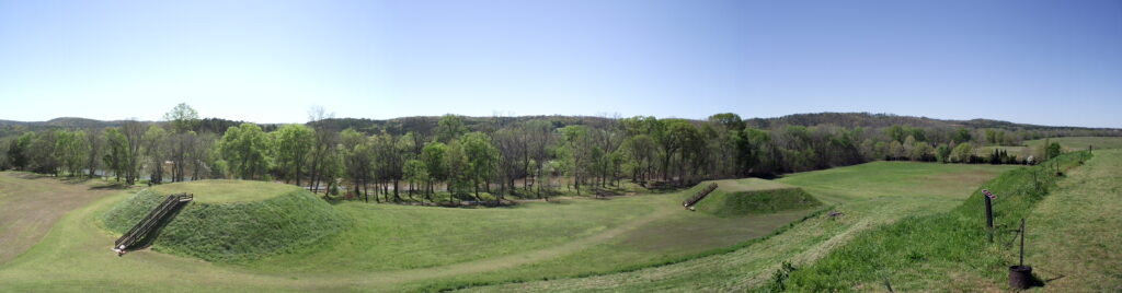
Etowah Indian Mounds, formerly Tumlin Mounds
It is the intention of this research to promote an educational understanding and awareness of American Indian mounds within Bartow County. Readers are alerted to be aware of state laws pertaining to the disturbance or removal of American Indian sites, burials and artifacts. Policies about American Indian Sites and Objects in Georgia are listed under The Official Code of Georgia Annotated (OCGA) 44-12-260 and (OCGA) 12-3-621 and specifically address protocol and violation consequences. Specific mound locations are omitted to protect sites from unauthorized and illegal plundering. As many of these locations have already been negatively impacted, please join the advocacy to protect and preserve these significant American Indian sites from further damage.
This work offers a fresh perspective of the presence of American Indian mounds and earthworks within Bartow County based on a review of archaeological survey data from the late 1800s and middle 1900s. A reexamination of this data highlights the fact that the area within Bartow County was a hub of mound building activity in the state for well over a millennium. While many people are aware that Bartow County is home to the Etowah Mounds, many may not know that the county once contained over two dozen individual mounds and earthworks. In fact, Bartow County contains more documented mound sites than any other surrounding county. These mounds were constructed during the Woodland and Mississippian periods, roughly from 200 B.C until the era of European arrival in the 1500s.
Why were mounds and earthworks constructed? The construction of mounds and other earthworks in the Eastern Woodlands of the US began as early as 5,400 years ago during the Middle Archaic period in the area of northern Louisiana. American Indians relate that mound sites are sacred places. Mound sites are an expression of the cosmological and ideological beliefs of the people who built them, and often served as places of aggregation for those who shared similar beliefs. Similar to a church community, people congregated to pool their time, labor, and other resources to create these places. Mounds were built in various forms, from conical to flat-topped, circular to elliptical, and these forms likely had specific connotations now known only to those who constructed them and their descendants. Mounds were often constructed in successive stages, with a new stage corresponding to the end of an era and beginning of a new one. They often buried people in or around mounds. Archaeologists have found evidence that they were places where both local and non-local peoples gathered and lived, places of pilgrimage, trade, ceremony, and cultural interaction.
In Bartow County, construction of the earliest known mound was begun during the Woodland period at the Leake site circa 2,100 years ago, while two additional mounds and a ditch enclosure similar to the one at Etowah were built at the site over the next 600 years. Across the river from Leake during this same period, people enclosed the summit of Ladd’s Mountain with a stone wall, buried a person in a log tomb and covered this tomb with stones, and used the large cave in the end of the mountain. Mound construction continued in the valley through much of the Mississippian period (1050-1541 AD), as exemplified by the well-preserved Etowah Mounds. Thus, mound building was practiced in the county for at least 1,500 years prior to Euroamerican settlement, and perhaps longer. This is a remarkable span of time when one compares that to the timeline of the United States, officially established just less than 250 years ago.
The primary concentration of mounds is in lower southeast Bartow County along the Etowah River. Mounds dotted both sides of the river westerly from the area of the Allatoona Dam continuing to Cartersville, Old Alabama Road, Pumpkinvine Creek, Highway 113, Ladd’s Mountain, and Raccoon Creek to Kingston. A smaller number of mounds have been documented as far north as Pine Log. While the Etowah Mounds offer a significant view of these stunning earthen constructions, many of the mounds in Bartow County (and other counties) have largely disappeared due to historic era land modifications and activities, including land clearing, farming, road construction, commercial and residential development, along with erosion that is often spurred by such activities. However, to the trained eye there remain telltale signs of ancient mounds that simply appear as humps, hills and outcroppings camouflaged in plain sight among trees, weeds, and fields. In other cases, level ground conceals the subsurface remnants of mounds.
Mound Inventory
The earliest known systematic documentation of mounds in Bartow County was conducted by researchers working for the Smithsonian Institution’s Bureau of Ethnology Division on Mound Exploration under the supervision of Cyrus Thomas (1891, 1894). The goal was to survey and document mound sites throughout the United States in the late 1800s. In sum, the Smithsonian documented 17 mound and earthwork sites, which consists of 26 earthen mounds, two stone enclosures, a stone mound, and a “vault”.
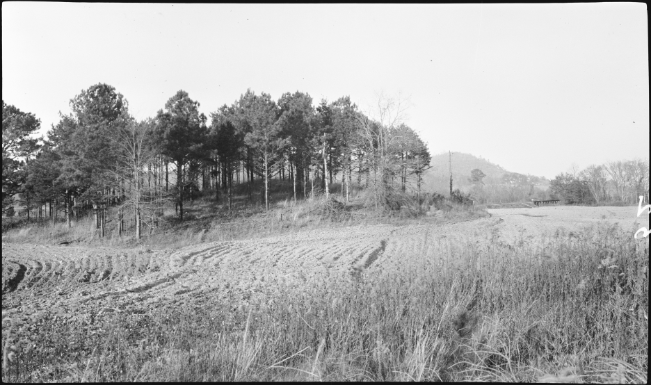
Anonymous , 1917 Indian Mound on Leake Property, 4 Mi. S.W. of Cartersville. Hu-52, Nov. 1917. Photograph mmg01-0052, State Geologist Photographs and Negative Files, Department of Mines, Mining, and Geology, RG 50-2-33, Georgia Archives, Morrow.
The following mound and earthwork sites in the county were documented during the Smithsonian’s effort:
Table 1. Mound and Earthwork sites documented by Cyrus Thomas (1891, 1894)
| Site Name/Reference | # of Mounds/ Earthworks | General Location |
| Etowah Group | 6 | Tumlin property |
| Parrott Mound | 1 | 3.5 miles west of Cartersville on north bank of river |
| Edwards Mound | 1 | Opposite Tumlin Farm and Etowah Group on south bank |
| Ben Akerman Mound | 1 | 7 miles west of Cartersville on east bank of Etowah River |
| Indian Fort | 1 | Summit of Ladd’s Mountain |
| Conyers Mound | 1 | Southeastern part of county on Euharlee Creek |
| Rowland Mounds* | 3 or 4 | South bank of river 4 miles west of Cartersville |
| Leap Mounds* | 3 | 3 miles west of Cartersville next to Cherokee RR |
| McGinnis Mound | 1 | Community/town of McGinnis |
| Adairsville Mound & Enclosure | 1 | Adairsville |
| Shellman Mound | 1 | 2 miles east of Stilesborough |
| Vault | 1 | 2 miles from Stilesborough on William Burgess’s farm |
| Rock Mound** | 1 | Near RR crossing at Pettit’s Creek |
| One Mound | 1 | Northern part of the county on Sim Mumford’s property |
| Two Mounds | 2 | North of Cartersville, site location not reported |
| Sam’s Mounds | 3 | Lewis Sam’s property across from Tumlin |
* “Rowland Mounds” currently known as Leake Mounds. “Leap Mounds” likely the same as Rowland Mounds.
**Likely the Shaw Mound
In the late 1930s prior to World War II, Robert Wauchope, an archaeologist then with the University of Georgia, conducted a survey of mounds and other significant American Indian sites in the northern portion of Georgia. Due to the war and his career afterward, his fieldwork was delayed until he returned to complete it in the late 1950s. The results of his work were not published until well after WWII by the Smithsonian Institution in 1966. Wauchope was able to relocate many of the mound sites recorded by the Smithsonian, but not all of them. The following is a list of existing and previously existing American Indian Mississippian Mounds found in Bartow County.
Table 2. Mound and Earthwork sites documented by Wauchope (1966).
| Site | # of Mounds/ Earthworks | Notes |
| Two Run Creek | 1 | between Cass Station and Kingston |
| Ben Akerman Mound | 1 | Smithsonian site near Akerman Ferry on river not relocated |
| Conyers Mound | 1 | Smithsonian site on Euharlee Creek not relocated |
| Conyers Farm | 1 | across from Etowah Mounds, not to be confused with Conyers Mound; may equate to Smithsonian Edwards Mound |
| Raccoon Creek | 1 | On Shellman Farm near Raccoon Creek, likely equates to Thomas’ Shellman Mound |
| Leak Mounds | 3 | South bank of river on Hwy 113 near Ladds Mt |
| Free Bridge | 1 | South bank of river west of Free Bridge, opposite Lewis Mound |
| Lewis Mound | 1 | North bank of river near, opposite Free Bridge Mound |
| Parrot Mound | 1 | Not relocated – corresponds to Thomas’ location for Lewis Mound but mound description differs |
| Etowah Mounds | 6 | North bank of river |
| Rowland Mounds | 3 | Erringly reported as southeast of Cartersville, did not realize it is the same as Leake Mounds |
| Sam’s Farm | 3 | Not relocated, may equate to Smithsonian Lewis Mound |
| Br-24 (Shaw Mound) | 1 | Stone mound at base of Ladds Mountain near quarry |
| Br-17 (Indian Fort) | 1 | Stone wall enclosing summit of Ladds Mountain |
Interestingly, Wauchope (1966:xvii) describes how the landscape had changed in the 20 years between his initial fieldwork (1938) and his terminal fieldwork (1958):
“I had expected that in twenty years a few old things might have changed, a footpath here or a fence there, perhaps a new highway cutting across my old familiar roads. But I was unprepared for the wholesale changes that had taken place; archaeologically speaking, we were lost most of the time. The old roads were almost all gone, or so improved as to be unrecognizable. New bridges spanned the rivers and creeks, with new approaches from different routes…our survey of the ‘thirties served another purpose: it located sites that might never again have been discovered”.
Even during their survey, the Smithsonian researchers occasionally noted the effects of years of plowing had on reducing the size of the mounds (e.g, Thomas 1884:312). Unfortunately, many of the mounds and earthworks built and used by American Indians in the county unfortunately have been largely erased by historic era activities. For example, the mounds at the Leake site were used for road fill of Highway 113 when it was rerouted to its current location, running directly over one of the mounds. The stone burial mound at the base of Ladd’s Mountain was dismantled, with the stones run through a rock crusher to generate gravel for road building. While the preserved Etowah Mounds are a highly visible reminder of the long history of people in the valley, there are remnants of other mounds across the county that are not visible above ground but rather are still present under the ground surface.
Currently, the repository for the state’s archaeological sites – the Georgia Archaeological Site Files housed at the University of Georgia – lists 19 American Indian mound and earthwork sites in Bartow County. Excluding the 10 mound sites recorded by the Smithsonian that archaeologists have since not been able to relocate on the ground, there are nine mound sites in the county with a known location. We know that the preservation and protection of these places is an important component of honoring an area’s heritage and history, of passing knowledge of the past to the younger generations, of keeping history alive. New technologies, such as ground penetrating radar and magnetometer, now provide archaeologists with powerful tools that can help detect subsurface deposits such as mound and earthworks, and one can only imagine what yet-to-be-developed technology will allow us to identify and learn about these places in the future. This is all the more reason to preserve and protect the remaining portions of mound and earthwork sites in Bartow County, and to be proactive in conducting archaeological studies prior to land development, for one never knows what bit of history may be hidden beneath our feet.
Conclusion
Although nearly 30 mounds and earthworks once defined the landscape now known as Bartow County, very few of the mounds documented within the county are still visible today. While they may not be visible on the surface, some portions of them may remain below the ground surface, which archaeological investigation can help determine. Far after their active life, these mounds stood as testament to a center of cultural development and interaction, a pilgrimage destination for over 1500 years for American Indians from near and far as they created and built these extraordinary sites. Due to their historical significance at local, regional, and even national levels, these American Indian sites not only deserve attention, but deserve additional documentation, preservation, and protection. As more land gets developed within the county, Bartow should promote this American Indian heritage and preserve what remains of these sites to help keep this unique legacy alive so that it can be enjoyed by future generations.
References Cited:
Thomas, Cyrus
1891 Catalogue of Prehistoric Works East of the Rocky Mountains. Bureau of Ethnology Bulletin 12:1-246. Smithsonian Institution, Bureau of American Ethnology, Washington, D.C.
1894 Report on the Mound Explorations of the Bureau of Ethnology. Twelfth Annual Report of the Bureau of American Ethnology to the Secretary of the Smithsonian Institution 1890-1891. Smithsonian Institution, Bureau of American Ethnology, Washington, D.C.
Wauchope, Robert L.
1966 Archaeological Survey of Northern Georgia. Society for American Archaeology, Memoir 21. University of Utah Printing Service, Salt Lake City, Utah.
Acknowledgements:
Thanks to David Archer, Sam Graham and Jim Langford for their in put.
About the authors:
Scot Keith is a Senior Archaeologist with Southern Research, Historic Preservation Consultants. He is a respected and innovative scientist specializing in Woodland period peoples of the Southeast and Midwestern regions of the United States and collaborates frequently with the Etowah Valley Historical Society.
Joe Head is Vice President of the Etowah Valley Historical Society and retired Dean of Enrollment Services at Kennesaw State University. He lectures, researches and writes frequently about Bartow County history.
____________________________
In the interest of learning more about the various mounds that were constructed in Bartow County, the EVHS would like to ask if you may have any old family photos that show mounds, or perhaps artifact collections from mound sites that could be used to determine the age and affiliation of mound sites.
