Where Was Sanfordville?
By Sam Graham
U.S. Postal records show that on June 21, 1831, a post office was established “Sandfordville”, Gwinnett County, Georgia, and that John Dawson was appointed postmaster.[i] In August of that year (1831) the Savannah Georgian reported that a post office had been established at “Sandfordsville, Gwinnett County, on the Hightower, on the mail route from Lawrenceville, Georgia to Bennettsville, Alabama”[ii]. The location “Gwinnett County, on the Hightower” reflects an act passed by the Georgia legislature, which placed all inhabitants of the Cherokee Indian lands under the jurisdiction of the state of Georgia. Any court cases arising in the Cherokee lands would be subject to the laws of Georgia, and heard in either Carroll, DeKalb, Gwinnett, Hall or Habersham Counties.[iii] The map below illustrates the Cherokee lands and adjacent counties:
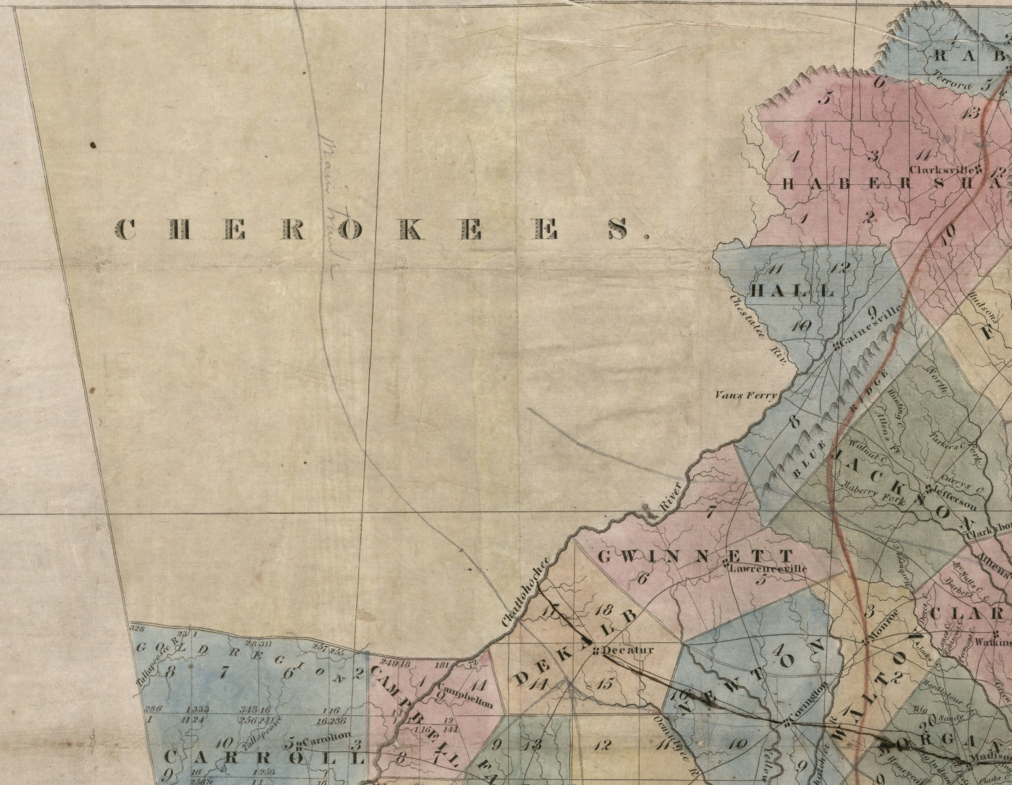
Figure 1: The Cherokee lands and adjacent Georgia Counties, 1830 [iv]
SANFORDVILLE INN
JOHN DAWSON respectfully tenders his thanks to his friends and to the public generally, for the patronage he has received, since the opening of his house in this place; and is now adding to his building, which will enable him to accommodate his visitors with comfort to them and satisfaction to himself.
His house is situated in the Gold region, on No 4, in the 3d section, near Sally Hughes’, on the west bank of the Hightower River, and on the main road from Milledgeville to Tennessee and North Alabama, and in the richest and most pleasant part of the Cherokee county. Good Mineral and Lime Stone Water.[v]
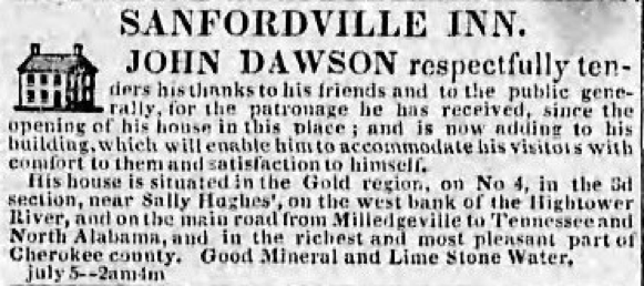
Figure 2: Advertisement from (Milledgeville) Georgia Journal, giving location of Sanfordville
The following detail from the District Map of Survey for Cherokee County, Section 3, Gold District 4, dated May 29, 1832, shows the location described in the advertisement. Sanfordville would have been on or near the southeast corner of land lot 621. Note the location of Sally Hughes’ house, on land lot 623:
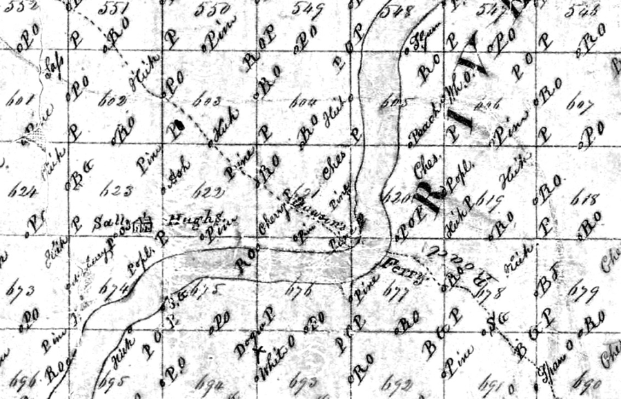
Figure 3: District Plat of Survey: Cherokee County, Section 3, Gold District 4, Courtesy of the Georgia Archives[vi]
This detail from the Bartow County tax maps shows the same area today:
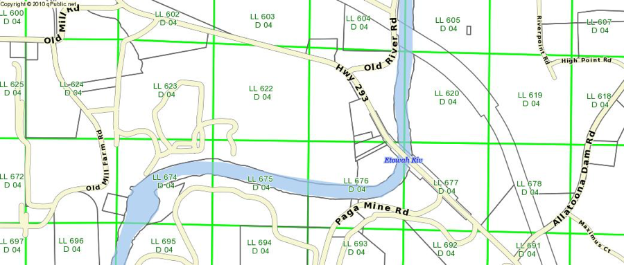
Figure 4: Detail from the Bartow County tax map (with land lots) showing the location of Sanfordville[vii]
On July 11, 1832, Sally Hughes wrote the following letter, complaining to the governor about the actions of John Dawson:
Cherokee Nation (Etowa) 11th July 1832
His excellency Governor Gilmore,
Sir, we the undersigned Cheerokee Women do remonstrate against the occupancy of a ferry on the Etowa River in the Cheerokee Nation by Messers Jesse Day and John Dosson, they have went over the Etowa River, one mile from where they had rented some land, and built several cabbins, erected a store, turn’d the public Road at least one half mile above where the road latterly cross’d the Etowa River and have erected a ferry and are transporting travelers a cross to the prejudice of the Indians (Viz) Walleneta, Charly Moore, and Sally Hughes one of the subscribers to this Memorial; the first subscribber to this memorial have twice complaind to Sergeant Jacob R Brooks, who is frequently through our Country executing the laws, his reply the last time was that he had forgot to name my complaint to Colo Santford, the Georgia agent and living at a remote distance from the said agent we have sent on this our complaint in behalf of Wallennetta Charley Moore and Sally Hughes the owners of the above namd ferry to you hoping that your Excellency will direct Colo. Santford the Georgia Agent to remove the said Jesse Day and John Dosson forthwith from the occupancy of the cabbins by them or either of them erected, as also from the occupancy of the said Ferry on the said Etowa River in the said Cheerokee Nation we need not say that we hope your Excellency will respect our rights, as Indians and cause to be done as to Justice shall appertain.
Standing Peachtree
Dekalb Co. Geo
Sign’d by us
Her
Sally X Hughes
Mark
Betsy Philips[viii]
On October 5, 1832, the following advertisement ran in the Athens newspaper the Southern Banner:
Sanfordville Inn.
JOHN DAWSON
Respectfully tender his thanks to his friends and to the public generally, for the patronage he has received since he opened his house at this place. He is now adding to his building, which will enable him to accommodate his visiters with comfort to them and satisfaction to himself. His house is situated on the West Bank of the Hightower River, (known on the map of the Cherokee country as Sally Hughe’s place,) on the mane road from Milledgeville to Tennessee and N. Alabama, an in the richest part of Cherokee country; in the vicinity are good mineral and limestone water and the Gold mines.[ix]
In July, 1833, Dawson advertised in the Columbus Enquirer, announcing his move to “Allatooney”. The ad noted that “the post office is removed from Sanfordville to this place.”
ALLATOONEY HOTEL.
THE Subscriber respectfully informs his friends and the public generally, that he has opened a house of entertainment, at the Allatooney Gold Mines, in Cass county, the above place is a handsome and healthy situation with the advantages of good spring and well water, and the pleasant mountain breeze, and is surrounded with a romantic forest, in the centre of the Gold Region, Allatooney, is 45 miles from the Carroll Mines, 70 from Auraria in Lumpkin county, and on the direct road leading from Auraria, to the Carroll mines.
- B. the post office is removed from Sanfordville to this place.
JOHN DAWSON[x]
On July 31, 1833, Spencer Riley advertised in the (Milledgeville) Southern Recorder that he had “located himself at Alatoona, Sanfordville Post Office, Cass county…”.[xi] So the post office had moved from Sanfordville to Allatoona, but it retained the name “Sanfordville Post Office”. The name wasn’t changed until 1838, as noted in the following:
Figure 5: (Milledgeville) Federal Union May 22, 1838[xii]
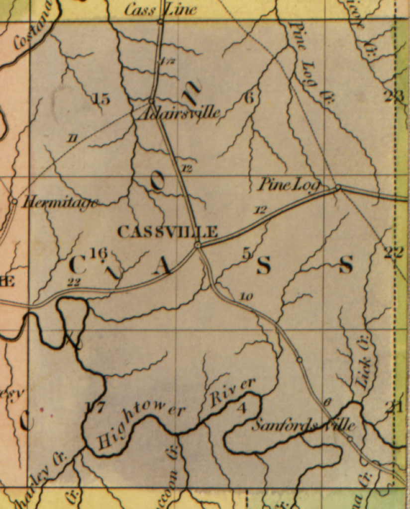
Figure 6: 1839, Cass County, Georgia. Note location of Sanfordville[xiv]
Sam Graham
October 27, 2016
[i] Record of Appointment of Postmasters, 1832-1971. NARA Microfilm Publication, M841, 145 rolls. Records of the Post Office Department, Record Group Number 28. Washington, D.C.: National Archives.
[ii] (Savannah) Georgian, August 30, 1831, The Savannah Historic Newspapers Archive, the Digital Library of Georgia
[iii] ACTS OF THE GENERAL ASSEMBLY OF THE State of Georgia, PASSED IN MILLEDGEVILLE AT AN ANNUAL SESSION IN NOVEMBER AND DECEMBER, 1829 Vol. 1 — Page: 98
[iv] Wellborn, C., Green, O. & Hoogland, W. (1830) Map of the state of Georgia, drawn from actual surveys and the most authentic information. [S.l.: s.n] [Map] Retrieved from the Library of Congress, https://www.loc.gov/item/2011588001/.
[v] Georgia Journal, 1809-1845, The Milledgeville Historic Newspapers Archive, the Digital Library of Georgia
[vi] District Plats of Survey, Survey Records, Surveyor General, RG 3-3-24, Georgia Archives
[vii] GIS map of Bartow County, Georgia; Bartow County Board of Assessors, http://qpublic7.qpublic.net/qpmap4/map.php?county=ga_bartow&layers=parcels+roads+lakes&mapmode.
[viii] Indians, Cherokee, File II, RG 4-2-46, Georgia Archives
[ix] Southern Banner, 1832-1882, The Athens Historic Newspapers Archive, the Digital Library of Georgia
[x] Columbus Enquirer, 1828-1861, The Columbus Enquirer Archive, the Digital Library of Georgia
[xi] Southern Recorder, 1820-1872, The Milledgeville Historic Newspapers Archive, the Digital Library of Georgia
[xii] Federal Union, 1830-1872, The Milledgeville Historic Newspapers Archive, the Digital Library of Georgia
[xiii] Article: The American Atlas, Library of Congress, https://www.wdl.org/en/item/9562/#contributors=Burr%2C+David+H.%2C+1803-1875.
[xiv] Burr, D. H. & Arrowsmith, J. (1839) The American atlas, exhibiting the post offices, post roads, rail roads, canals, and the physical & political divisions of the United States of North America. [London?: John Arrowsmith] [Map] Retrieved from the Library of Congress, https://www.loc.gov/item/2009582191/.
[1] Record of Appointment of Postmasters, 1832-1971. NARA Microfilm Publication, M841, 145 rolls. Records of the Post Office Department, Record Group Number 28. Washington, D.C.: National Archives.
[1] (Savannah) Georgian, August 30, 1831, The Savannah Historic Newspapers Archive, the Digital Library of Georgia
[1] ACTS OF THE GENERAL ASSEMBLY OF THE State of Georgia, PASSED IN MILLEDGEVILLE AT AN ANNUAL SESSION IN NOVEMBER AND DECEMBER, 1829 Vol. 1 — Page: 98
[1] Wellborn, C., Green, O. & Hoogland, W. (1830) Map of the state of Georgia, drawn from actual surveys and the most authentic information. [S.l.: s.n] [Map] Retrieved from the Library of Congress, https://www.loc.gov/item/2011588001/.
[1] Georgia Journal, 1809-1845, The Milledgeville Historic Newspapers Archive, the Digital Library of Georgia
[1] District Plats of Survey, Survey Records, Surveyor General, RG 3-3-24, Georgia Archives
[1] GIS map of Bartow County, Georgia; Bartow County Board of Assessors, http://qpublic7.qpublic.net/qpmap4/map.php?county=ga_bartow&layers=parcels+roads+lakes&mapmode.
[1] Indians, Cherokee, File II, RG 4-2-46, Georgia Archives
[1] Southern Banner, 1832-1882, The Athens Historic Newspapers Archive, the Digital Library of Georgia
[1] Columbus Enquirer, 1828-1861, The Columbus Enquirer Archive, the Digital Library of Georgia
[1] Southern Recorder, 1820-1872, The Milledgeville Historic Newspapers Archive, the Digital Library of Georgia
[1] Federal Union, 1830-1872, The Milledgeville Historic Newspapers Archive, the Digital Library of Georgia
[1] Article: The American Atlas, Library of Congress, https://www.wdl.org/en/item/9562/#contributors=Burr%2C+David+H.%2C+1803-1875.
[1] Burr, D. H. & Arrowsmith, J. (1839) The American atlas, exhibiting the post offices, post roads, rail roads, canals, and the physical & political divisions of the United States of North America. [London?: John Arrowsmith] [Map] Retrieved from the Library of Congress, https://www.loc.gov/item/2009582191/.