EP = Early Pioneers and Settlers of Bartow County
Interactive Map of Georgia Land Lottery in Bartow County
Native Americans first occupied this region for thousands of years and established impressive townships throughout Bartow County. A surviving Mississippian example is the Etowah Indian Mounds located on the Etowah River. Here they farmed, hunted and ate a diet of corn, squash, beans, venison … roasting meats and fresh fish or mussels from the Etowah River. Lesser known or forgotten townships such as the pre-historic Leake Mound site on Highway 113 and Cherokee Pine Log site in northeast Bartow County are other examples of townships. It should be noted that early Native American occupation of Bartow County can be divided between the Woodland/Mississippian period and the more modern Creek and Cherokee periods.
Early white settlers were initially drawn to north Georgia as a result of America’s first gold rush in Dahlonega (Lumpkin County). The trail of gold led southwest and lightly traced through Bartow County. Prospectors discovered little gold, but found unexpected large deposits of profitable ores and minerals. As a result, Bartow first became an early mining industry. However, the untamed land was inhabited by the Cherokee Indian Nation and could not be easily settled by the westward bound frontiersmen.
Prior to 1800 Georgia was considered to be the western frontier inhabited by Creek and Cherokee Indians. Migration into North Georgia largely came from North and South Carolina, Virginia and East Tennessee. Bartow/Cass County, among other counties, was established out of the larger “Cherokee” district. In 1832 the Cherokee Land Lottery created Cass County, with Cassville as the original county seat named after Lewis Cass, Secretary of War under President Andrew Jackson. According to Lucy Cunyus, author of “History of Bartow County, Georgia – Formerly Cass,” land grants were parceled according to 40 – acre gold lots or 160 – acre land lots to distinguish between the potential value. In 1850 Cass County was divided to create Gordon County.
Early furnaces were first introduced by Carolinians Jacob and Moses Stroup along Stamp Creek in the 1830’s. These four-sided furnaces were constructed of stone and shaped similar to Egyptian pyramids, but with a flat top and rising between 20 to 30 feet in height. Later, Major Mark Anthony Cooper learned the furnace business from the Stroups. He built and operated a primary furnace that became known as “Cooper’s Furnace” at the rolling mill town of Etowah on the river until the Civil War. Records indicate there were 9 to 12 cupelo stone furnaces built between the 1830’s and 1860’s, known as the golden age of the Hills of Iron in Bartow County. Click here to see mining industry in Bartow County.
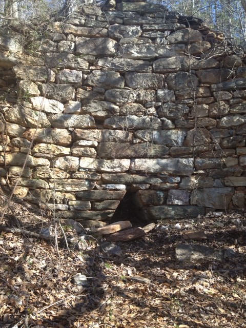
Emerson Stone Kiln Furnace
Bartow was primarily known for iron ore furnaces, but limestone and cement kiln furnaces were also constructed during this period. They were a bit smaller and are often confused to be iron ore furnaces.
Click here for an example of how a stone iron ore furnace from this period operates.
Cass was recognized to be rich with fertile soil, space, timber, climate, ore, water and opportunity. Settlers needed unmolested access and a means to claim the land. As a result the Cherokees were removed to Indian territory, in present day Oklahoma by order of President Andrew Jackson on what is now known as the “Trail of Tears” for re-patriotization.
In the late 1830’s the Georgia Legislature approved the construction of a state – owned railroad which was surveyed between Atlanta and Chattanooga. The railroad was named the “Western and Atlantic” in honor of its mission to connect western commerce routes (Mississippi River) with the Atlantic transportation routes via the Savannah River in Augusta. The county seat, Cassville, chose to initially be exempt from the survey route, therefore moving the tracks two miles southwest of the city. It is said this decision was to prevent noise, pollution, frightening live stock and traffic congestion in the heart of the city. However, after some reflection the city asked for the route to be redirected through the town, but it was too late unless the city wished to fund the alteration. As a result, the railroad was not constructed through Cassville and eventually led to severe consequences after the Civil War.
Other early influential citizens would include: Farish Carter for whom Cartersville is named, William Henry Stiles for whom Stileboro is named, Warren Akin, Sr., who argued the state’s first four supreme court decisions in Cassville, Henry and Lewis Tumlin who owned and preserved the Etowah Indian Mounds and Amos Tappan Akerman who established the predecessor to the current day FBI.
For an expanded list of other prominent Bartow County personalities see “People” under the Bartow History tab on the home page.
List assorted EP Factoids:
1. Adairsville was named for an early Scotch settlement in north Bartow County.
2. Author Lucy Cunyus wrote the early history of Bartow and Cass County.
3. The Cherokee Indian lands in Bartow County were distributed by a lottery in 1832, and this action was known as the “Cherokee or Georgia Land Lottery.”
4. When Cass County was first created in 1832 it included much of Gordon County, but later re-partitioned.
5. The first post office established in what was to become Cartersville was called, The Cherokee Post Office.
6. The Warren Akin law practice is the longest continuing family practice in the state and is currently known as “Akin and Tate”
7. Cass County was divided in 1850 to create Gordon County.
Back to Scholar Topics
Back to Bartow History Scholars
Bartow History Scholars Tutorial
